Section 1. NAVAID Use Limitations
- Views Views: 2,669
- Last updated Last updated:
-
Sub-pages:
Section 1. NAVAID Use Limitations
4-1-1. ALTITUDE AND DISTANCE LIMITATIONS
When specifying a route other than an established airway or route, do not exceed the limitations in the table on any portion of the route which lies within controlled airspace. (For altitude and distance limitations, see TBL 4-1-1, TBL 4-1-2, and TBL 4-1-3) (For correct application of altitude and distance limitations see FIG 4-1-1 and FIG 4-1-2.)
TBL 4-1-1 VOR/VORTAC/TACAN NAVAIDs
Normal Usable Altitudes and Radius DistancesClass Altitude Distance (miles) T 12,000 and below 25 L Below 18,000 40 H Below 14,500 40 H 14,500 - 17,999 100 H 18,000 - FL 450 130 H Above FL 450 100 TBL 4-1-2 L/MF Radio Beacon (RBN)
Usable Radius Distances for All AltitudesClass Power (watts) Distance (miles) CL Under 25 15 MH Under 50 25 H 50 - 1,999 50 HH 2000 or more 75 TBL 4-1-3 ILS Usable Height and Distance* Height (feet) above transmitter Distance (miles from transmitter) 4,500 10 (for glideslope) 4,500 18 (for localizer) *Use the current flight check height/altitude limitations if different from the above minima. FIG 4-1-1 Application of Altitude and Distance Limitations [Application 1] 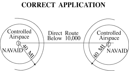
FIG 4-1-2 Application of Altitude and Distance Limitations [Application 2] 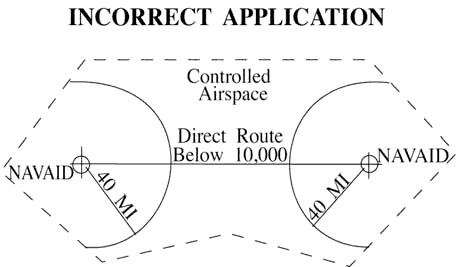
4-1-2. EXCEPTIONS
Altitude and distance limitations need not be applied when any of the following conditions are met:
-
Routing is initiated by ATC or requested by the pilot and radar monitoring is provided.
EXCEPTION: GNSS equipped aircraft /G, /L, /S, and /V not on a random impromptu route.
- NOTE:
- 1. Except for GNSS equipped aircraft /G, /L, /S, and /V, not on a random impromptu route, Paragraph 5-5-1, Application, requires radar separation be provided to RNAV aircraft operating at and below FL450 on Q routes or random RNAV routes, excluding oceanic airspace.
- 2. When a clearance is issued beyond the altitude and/or distance limitations of a NAVAID, in addition to being responsible for maintaining separation from other aircraft and airspace, the controller is responsible for providing aircraft with information and advice related to significant deviations from the expected flight path.
- REFERENCE
- FAA Order JO 7110.65, Para 2-1-3, Procedural Preference.
- FAA Order JO 7110.65, Para 4-4-2, Route Structure Transitions.
- FAA Order JO 7110.65, Para 5-1-6, Deviation Advisories.
- FAA Order JO 7110.65, Para 5-5-1, Application.
- FAA Order JO 7110.65, Para 6-5-4, Minima Along Other Than Established Airways or Routes.
- AIM, Para 5-1-8c, Direct Flights.
- AIM, Para 5-1-8d, Area Navigation (RNAV).
- P/CG Term - Global Navigation Satellite System (GNSS)[ICAO].
- Operational necessity requires and approval has been obtained from the Frequency Management and Flight Inspection Offices to exceed them.
- Requested routing is via an MTR.
4-1-3. CROSSING ALTITUDE
Use an altitude consistent with the limitations of the aid when clearing an aircraft to cross or hold at a fix.
4-1-4. VFR-ON-TOP
Use a route not meeting service volume limitations only if an aircraft requests to operate “VFR-on-top” on this route.
- NOTE:
- Aircraft equipped with TACAN only are expected to:
- 1. Define route of flight between TACAN or VORTAC NAVAIDs in the same manner as VOR-equipped aircraft.
- 2. Except in Class A airspace, submit requests for “VFR-on-top” flight where insufficient TACAN or VORTAC NAVAIDs exist to define the route.
4-1-5. FIX USE
Request aircraft position reports only over fixes shown on charts used for the altitude being flown, except as follows:
NOTE: Waypoints filed in random RNAV routes automatically become compulsory reporting points for the flight unless otherwise advised by ATC.
- Unless the pilot requests otherwise, use only those fixes shown on high altitude en route charts, high altitude instrument approach procedures charts, and SID charts when clearing military turbojet single-piloted aircraft.
- Except for military single-piloted turbojet aircraft, unpublished fixes may be used if the name of the NAVAID and, if appropriate, the radial/course/ azimuth and frequency/channel are given to the pilot. An unpublished fix is defined as one approved and planned for publication which is not yet depicted on the charts or one which is used in accord with the following:
- REFERENCE
- FAA Order 8260.3, United States Standard for Terminal Instrument Procedures (TERPS), Chapter 17, Basic Holding Criteria.
- Unpublished fixes are formed by the en route radial and either a DME distance from the same NAVAID or an intersecting radial from an off-route VOR/VORTAC/TACAN. DME must be used in lieu of off-route radials, whenever possible.
- Except where known signal coverage restrictions exist, an unpublished fix may be used for ATC purposes if its location does not exceed NAVAID altitude and distance limitation, and when off-route radials are used, the angle of divergence meets the criteria prescribed below.
NOTE: Unpublished fixes should not negate the normal use of published intersections. Frequent routine use of an unpublished fix would justify establishing a fix.
- Do not hold aircraft at unpublished fixes below the lowest assignable altitude dictated by terrain clearance for the appropriate holding pattern airspace area (template) regardless of the MEA for the route being flown.
- When the unpublished fix is located on an off-route radial and the radial providing course guidance, it must be used consistent with the following divergence angles:
- (a) When holding operations are involved with respect to subparas (b) and (c) below, the angle of divergence must be at least 45 degrees.
- (b) When both NAVAIDs involved are located within 30 NM of the unpublished fix, the minimum divergence angle is 30 degrees.
- (c) When the unpublished fix is located over 30 NM from the NAVAID generating the off-course radial, the minimum divergence angle must increase 1 degree per NM up to 45 NM; e.g., 45 NM would require 45 degrees.
- (d) When the unpublished fix is located beyond 45 NM from the NAVAID generating the off-course radial, the minimum divergence angle must increase 1/2 degree per NM; e.g., 130 NM would require 88 degrees.
- Fixes contained in the route description of MTRs are considered filed fixes.
- TACAN-only aircraft (type suffix M, N, or P) possess TACAN with DME, but no VOR or LF navigation system capability. Assign fixes based on TACAN or VORTAC facilities only.
NOTE: TACAN-only aircraft can never be held overhead the NAVAID, be it TACAN or VORTAC.
- DME fixes must not be established within the no-course signal zone of the NAVAID from which inbound holding course information would be derived.
-
Routing is initiated by ATC or requested by the pilot and radar monitoring is provided.