2-3-2. EN ROUTE DATA ENTRIES
- Views Views: 1,589
- Last updated Last updated:
-
2-3-2. EN ROUTE DATA ENTRIES
Fig. 2-3-2 Flight Progress Strip (7230-19) 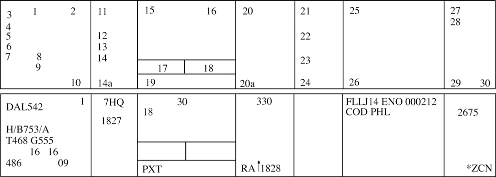
- Information recorded on the flight progress strips (FAA Forms 7230-19) must be entered in the correspondingly numbered spaces:
TBL 2-3-1 Block Information Recorded 1. Verification symbol if required. 2. Revision number.
DSR - Not used.3. Aircraft identification. 4. Number of aircraft if more than one, heavy aircraft indicator “H/” if appropriate, type of aircraft, and aircraft equipment suffix. 5. Filed true airspeed. 6. Sector number. 7. Computer identification number if required. 8. Estimated ground speed. 9. Revised ground speed or strip request (SR) originator. 10. Strip number.
DSR - Strip number/Revision number.11. Previous fix. 12. Estimated time over previous fix. 13. Revised estimated time over previous fix. 14. Actual time over previous fix, or actual departure time entered on first fix posting after departure. 14a. Plus time expressed in minutes from the previous fix to the posted fix. 15. Center-estimated time over fix (in hours and minutes), or clearance information for departing aircraft. 16. Arrows to indicate if aircraft is departing (↑) or arriving (↓). 17. Pilot-estimated time over fix. 18. Actual time over fix, time leaving holding fix, arrival time at nonapproach control airport, or symbol indicating cancellation of IFR flight plan for arriving aircraft, or departure time (actual or assumed). 19. Fix. For departing aircraft, add proposed departure time. 20. Altitude information (in hundreds of feet) or as noted below. NOTE: Altitude information may be written in thousands of feet provided the procedure is authorized by the facility manager, and is defined in a facility directive, i.e. FL 330 as 33, 5,000 feet as 5, and 2,800 as 2.8.
20a. OPTIONAL USE, when voice recorders are operational;
REQUIRED USE, when the voice recorders are not operating and strips are being use at the facility. This space is used to record reported RA events. The letters RA followed by a climb or descent arrow (if the climb or descent action is reported) and the time (hhmm) the event is reported.21. Next posted fix or coordination fix. 22. Pilot's estimated time over next fix. 23. Arrows to indicate north (↑), south (↓), east (→), or west (←) direction of flight if required. 24. Requested altitude. NOTE: Altitude information may be written in thousands of feet provided the procedure is authorized by the facility manager, and is defined in a facility directive, i.e., FL 330 as 33, 5,000 feet as 5, and 2,800 as 2.8.
25. Point of origin, route as required for control and data relay, and destination. 26. Pertinent remarks, minimum fuel, point out/radar vector/speed adjustment information or sector/position number (when applicable in accordance with para 2-2-1, Recording Information), or NRP. 27. Mode 3/A beacon code if applicable. 28. Miscellaneous control data (expected further clearance time, time cleared for approach, etc.). 29-30. Transfer of control data and coordination indicators. - Latitude/longitude coordinates may be used to define waypoints and may be substituted for nonadapted NAVAIDs in space 25 of domestic en route flight progress strips provided it is necessary to accommodate a random RNAV or GNSS route request.
- Facility air traffic managers may authorize the optional use of spaces 13, 14, 14a, 22, 23, 24, and 28 for point out information, radar vector information, speed adjustment information, or transfer of control data.
- Information recorded on the flight progress strips (FAA Forms 7230-19) must be entered in the correspondingly numbered spaces: