The ATOP system displays information on electronic flight progress strips and, in the event of a catastrophic system failure, will print flight progress strips with data in the corresponding numbered spaces:
TBL 2-3-2
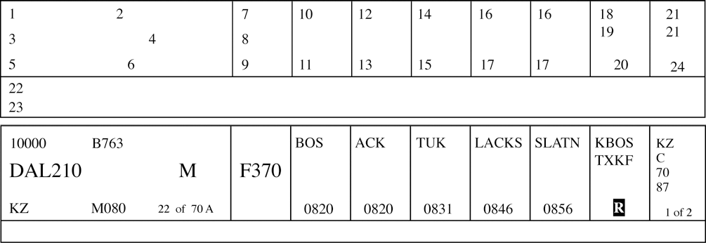
Block
Information Recorded
1.
Mode 3/A beacon code, if applicable.
2.
Number of aircraft, if more than one, and type of aircraft.
3.
Aircraft identification.
4.
Reduced separation flags.
Indicators are available for:
M - Mach Number Technique (MNT),
R - Reduced MNT,
D or 3 - Distance-based longitudinal separation using 50 NM (D) or 30 NM (3), and
W - Reduced Vertical Separation Minimum (RVSM).
These flags are selectable for aircraft whose flight plans contain the required equipment qualifiers for each separation criteria.
5.
Controlling sector number.
6.
Filed airspeed or assigned Mach number/True airspeed.
7.
Reported flight level. May contain an indicator for a flight that is climbing (↑) or descending (↓). Reports from Mode C, ADS or position reports are displayed in that order of preference.
8.
Cleared flight level. May contain an indicator for a future conditional altitude ( * ) that cannot be displayed.
9.
Requested flight level, if applicable.
10.
Previously reported position.
Block
Information Recorded
11.
Actual time over previously reported position.
12.
Last reported position.
13.
Actual time over last reported position.
14.
Next reporting position.
15.
In-conformance pilot's estimate or controller-accepted pilot's estimate for next reporting position.
16.
Future reporting position(s).
17.
System estimate for future reporting position(s).
18.
Departure airport or point of origin.
19.
Destination airport or filed point of flight termination.
20.
Indicators. Indicators and toggles for displaying or suppressing the display of the route of flight (F), second flight profile (2), radar contact (A), annotations (&), degraded Required Navigation Performance (RNP, indicator R) and clearance restrictions (X).
21.
Coordination indicator(s).
22.
Annotations.
23.
Clearance restrictions and conditions (may be multiple lines).
24.
Strip number and total number of strips (printed strips only).
Standard annotations and abbreviations for Field 22 may be specified by facility directives.
Much more information and resources are available to registered users, so sign up now! Also, please read our site usage guidelines. These will help you get the most out of the site. Thanks!