6-5-4. MINIMA ALONG OTHER THAN ESTABLISHED AIRWAYS OR ROUTES
- Views Views: 1,291
- Last updated Last updated:
-
6-5-4. MINIMA ALONG OTHER THAN ESTABLISHED AIRWAYS OR ROUTES
Protect airspace along other than established airways or routes as follows: (See FIG 6-5-4.)
FIG 6-5-4 Minima Along Other Than Established Airways or Routes 
- REFERENCE
- P/CG Term - Airway.
- P/CG Term - Route.
- Direct courses and course changes of 15 degrees or less:
- Via NAVAIDs or radials FL 600 and below- 4 miles on each side of the route to a point 51 miles from the NAVAID, then increasing in width on a 4 1/2 degree angle to a width of 10 miles on each side of the route at a distance of 130 miles from the NAVAID.
- Via degree-distance fixes for aircraft authorized under para 4-4-3, Degree-Distance Route Definition for
Military Operations.
- (a) Below FL180- 4 miles on each side of the route.
- (b) FL 180 to FL 600 inclusive- 10 miles on each side of the route.
- Via degree-distance fixes for RNAV flights above FL 450- 10 miles on each side of the route.
NOTE: Except for GNSS-equipped aircraft /G, /L, /S, and /V, not on a random impromptu route, Paragraph 5-5-1, Application, requires radar separation be provided to RNAV aircraft operating at and below FL450 on Q routes or random RNAV routes, excluding oceanic airspace.
- GNSS-equipped RNAV aircraft provided non-radar separation on random RNAV routes must be cleared via or
reported to be established on point-to-point route segments.
- (a) The points must be published NAVAIDs, waypoints, fixes, or airports recallable from the aircraft's navigation database. The points must be displayed on controller video maps or depicted on the controller chart displayed at the control position. The maximum distance between points must not exceed 500 miles.
- (b) Protect 4 miles either side of the route centerline.
- (c) Assigned altitudes must be at or above the highest MIA along the projected route segment being
flown, including the protected airspace of that route segment.
- EXAMPLE
- A pilot has filed a point-to-point route from XYZ to ABC at 13,000 feet. Departure procedures from the originating airport place the aircraft a significant distance from XYZ; however, the aircraft can establish itself along the route segment from XYZ to ABC. Ascertain when the pilot is established on the point-to-point route segment and at an altitude that meets or exceeds the highest MVA/MIA projected along the route of flight, then issue a clearance. “Verify when you are established on the XYZ to ABC route segment at or above 6,000 feet.”
- (d) When the GNSS aircraft is being provided radar service and is transitioning to non-radar airspace, provide clearance direct to the named point in non-radar airspace in accordance with subparagraphs a4(a) through (c).
- If transitioning between two random point-to-point routes, GNSS-equipped aircraft being provided non-radar
separation may be cleared via an impromptu route when the following conditions are met:
- (a) The impromptu route segment must not exceed the distance to the nearest available recallable fix/waypoint consistent with the direction of flight; and
- (b) Assigned altitudes must beat or above the highest MIA along the projected route segment being flown; and
- (c) Aircraft conducting the impromptu route must be separated vertically from other aircraft until established on the new point-to-point route.
- When course change is 16 degrees through 90 degrees, protect the airspace on the overflown side beginning at the
point where the course changes as follows: (See FIG 6-5-5.)
FIG 6-5-5 Overflown Side Minima 16 to 90 Degrees 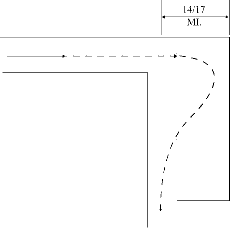
- Below FL 180- same as subparagraphs a1 or 2.
- FL 180 to FL 230 inclusive- 14 miles.
- Above FL230 to FL600 inclusive- 17miles.
- When course change is 91 degrees through 180 degrees, protect the airspace on the overflown side beginning at
the point where the course changes as follows: (See FIG 6-5-6.)
- Below FL 180- same as subparagraphs a1 or 2.
- FL 180 to FL 230 inclusive- 28 miles.
- Above FL230 to FL600 inclusive- 34miles.
FIG 6-5-6 Overflown Side Minima 91 to 180 Degrees 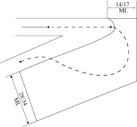
- After the course changes specified in subparagraphs b or c have been completed and the aircraft is back on course, the appropriate minima in subparagraph a may be used.