Section 1. Introduction
1-1-1. PURPOSE OF THIS ORDER
This order prescribes air traffic control procedures and phraseology for use by persons providing air traffic control services. Controllers are required to be familiar with the provisions of this order that pertain to their operational responsibilities and to exercise their best judgment if they encounter situations that are not covered by it.
1-1-2. AUDIENCE
This order applies to all ATO personnel and anyone using ATO directives.
1-1-3. WHERE TO FIND THIS ORDER
This order is available on the FAA Web site at http://www.faa.gov/regulations_policies/orders_notices.
1-1-4. WHAT THIS ORDER CANCELS
FAA Order JO 7110.65Z, Air Traffic Control, dated June 17, 2021, and all changes to it are canceled.
1-1-5. EXPLANATION OF CHANGES
The significant changes to this order are identified in the Explanation of Changes page(s). It is advisable to retain the page(s) throughout the duration of the basic order.
1-1-6. EFFECTIVE DATES AND SUBMISSIONS FOR CHANGES
- This order and its changes are scheduled to be published to coincide with AIRAC dates. (See TBL 1-1-1.)
- The “Cutoff Date for Completion” in the table below refers to the deadline for a proposed change to be fully coordinated and signed. Change initiators must submit their proposed changes well in advance of this cutoff date to meet the publication effective date. The process to review and coordinate changes often takes several months after the change is initially submitted.
| Basic or Change | Cutoff Date for Completion | Effective Date of Publication |
|---|---|---|
| JO 7110.65AA | 11/3/22 | 4/20/23 |
| Change 1 | 4/20/23 | 10/5/23 |
| Change 2 | 10/5/23 | 3/21/24 |
| Change 3 | 3/21/24 | 9/5/24 |
| JO 7110.65BB | 9/5/24 | 2/20/25 |
| Change 1 | 2/20/25 | 8/7/25 |
| Change 2 | 8/7/25 | 1/22/26 |
| Change 3 | 1/22/26 | 7/29/26 |
1-1-7. DELIVERY DATES
- If an FAA facility has not received the order/changes at least 30 days before the above effective dates, the facility must notify its service area office distribution officer.
- If a military facility has not received the order/changes at least 30 days before the above effective dates, the facility must notify its appropriate military headquarters. (See TBL 1-1-2.)
| Military Headquarters | DSN | Commercial |
|---|---|---|
| U.S. Army USAASA | 656-4868 | (703) 806-4868 |
| U.S. Air Force HQ AFFSA | 884-5509 | (405) 734-5509 |
| U.S. Navy CNO (N980A) | 224-2638 | (703) 614-2638 |
1-1-8. RECOMMENDATIONS FOR PROCEDURAL CHANGES
The office of primary responsibility (OPR) for this order is:
- FAA Headquarters, Mission Support Services
- Policy (AJV-P)
- 600 Independence Avenue, SW Washington, DC 20597
- Personnel should submit recommended changes in procedures to facility management.
- Recommendations from other sources should be submitted through appropriate FAA, military, or industry/user channels.
- Proposed changes must be submitted electronically to [email protected]. The submission should include a description of the recommended change, and the proposed language to be used in the order.
NOTE: For details on the submission process as well as additional AJV-P processing responsibilities, please see FAA Order JO 7000.5 Procedures for Submitting Changes to Air Traffic Control Publications.
- Procedural changes will not be made to this order until the operational system software has been adapted to accomplish the revised procedures
1-1-9. REQUESTS FOR INTERPRETATIONS OR CLARIFICATIONS TO THIS ORDER
- Interpretation requests from field air traffic personnel must be submitted as follows:
- The request must be submitted,in writing,by an Air Traffic Facility/General manager to their Service Area Director.
- The Service Area Director must review the request and determine if more than one interpretation on the intent of the language can be inferred.
- If it is determined that an interpretation is required, the Service Area Director must submit the request, in writing, to the Policy Directorate, for a response.
- If a request does not require an interpretation but further clarification is needed it must be forwarded to the Service Center Operations Support Group for a response.
- The Service Center Operations Support Group may consult with the Policy Directorate when preparing their response.
- The Service Center Operations Support Group must provide a written response to the requestor and forward the response to the Policy Directorate.
- Interpretation requests from all other sources must be submitted to the Policy Directorate at [email protected]
NOTE: Interpretations can be accessed through the Air Traffic Control Interpretation link at the following website: https://my.faa.gov/org/linebusiness/ato/mission_support/psgroup/atc_interpretations.html.
1-1-10. PROCEDURAL LETTERS OF AGREEMENT
Procedures/minima which are applied jointly or otherwise require the cooperation or concurrence of more than one facility/organization must be documented in a letter of agreement. Letters of agreement only supplement this order. Any minima they specify must not be less than that specified herein unless appropriate military authority has authorized application of reduced separation between military aircraft.
- REFERENCE
- FAA Order JO 7110.65, Para 2-1-1, ATC Service.
- FAA Order JO 7210.3, Para 4-3-1, Letters of Agreement.
1-1-11. CONSTRAINTS GOVERNING SUPPLEMENTS AND PROCEDURAL DEVIATIONS
- Exceptional or unusual requirements may dictate procedural deviations or supplementary procedures to this order. Prior to implementing supplemental or any procedural deviation that alters the level, quality, or degree of service, obtain prior approval from the Vice President, Mission Support Services.
- If military operations or facilities are involved, prior approval by the following appropriate headquarters is required for subsequent interface with FAA. (See TBL 1-1-3.)
| Branch | Address |
|---|---|
| U.S. Navy |
|
| U.S. Air Force |
|
| U.S. Army |
|
NOTE: Terminal: Headquarters Air Force Flight Standards Agency is the approval authority for any USAF procedures or minima that differ from those specified herein and that involve military aircraft only.
1-1-12. SAFETY MANAGEMENT SYSTEM (SMS)
Every employee is responsible to ensure the safety of equipment and procedures used in the provision of services within the National Airspace System (NAS). Risk assessment techniques and mitigations, as appropriate, are intended for implementation of any planned safety significant changes within the NAS, as directed by FAA Order 1100.161, Air Traffic Safety Oversight. Direction regarding the SMS and its application can be found in the FAA Safety Management System Manual and FAA Order 1100.161. The SMS will be implemented through a period of transitional activities. (Additional information pertaining to these requirements and processes can be obtained by contacting the service area offices.)
1-1-13. REFERENCES TO FAA NON-AIR TRAFFIC ORGANIZATIONS
When references are made to regional office organizations that are not part of the Air Traffic Organization (i.e., Communications Center, Flight Standards, Airport offices, etc.), the facility should contact the FAA region where the facility is physically located - not the region where the facility's service area office is located.
1-1-14. DISTRIBUTION
This order is distributed to selected offices in Washington headquarters, regional offices, service area offices, the William J. Hughes Technical Center, and the Mike Monroney Aeronautical Center. Also, copies are sent to all air traffic field facilities and international aviation field offices; and to interested aviation public.
Section 2. Terms of Reference
1-2-1. WORD MEANINGS
As used in this order:
- “Shall” or “must” means a procedure is mandatory.
- “Shall not” or “must not” means a procedure is prohibited.
- “Should” means a procedure is recommended.
- “May” or “need not” means a procedure is optional.
- “Will” means futurity, not a requirement for the application of a procedure.
- Singular words include the plural.
- Plural words include the singular.
- “Aircraft” means the airframe, crew members, or both.
- “Approved separation” means separation in accordance with the applicable minima in this order.
- “Altitude” means indicated altitude mean sea level (MSL), flight level (FL), or both.
- “Miles” means nautical miles unless otherwise specified, and means statute miles in conjunction with visibility.
- “Course,” “bearing,” “azimuth,” “heading,” and “wind direction” information must always be magnetic unless specifically stated otherwise.
- “Time” when used for ATC operational activities, is the hour and the minute in Coordinated Universal Time (UTC). Change to the next minute is made at the minute plus 30 seconds, except time checks are given to the nearest quarter minute.
- “Runway” means the runway used by aircraft and, unless otherwise specified, does not include helipads and/or their accompanying takeoff/landing courses. (See Pilot/Controller Glossary terms - Runway and Helipad.)
-
Flight operations in accordance with the options of “due regard” or “operational” have the following requirements:
-
Obligates the authorized state aircraft commander to:
- (a) Separate his/her aircraft from all other air traffic; and
- (b) Assure that an appropriate monitoring agency assumes responsibility for search and rescue actions; and
-
(c) Operate under at least one of the following conditions:
- (1) In visual meteorological conditions (VMC); or
- (2) Within an area that is covered by an ATC surveillance source and in communications with ATC, or within surveillance source service volume and radio communications range of a facility, Department of Homeland Security or DoD unit capable of providing the pilot assistance to operate with due regard to other aircraft; or
- (3) Be equipped with airborne radar that is sufficient to provide separation between his/her aircraft and any other aircraft he/she may be controlling and other aircraft; or
- (4) Operate within Class G airspace.
- An understanding between the pilot and controller regarding the intent of the pilot and the status of the flight should be reached before the aircraft leaves ATC frequency.
- NOTE:
- 1. A pilot's use of the phrase “Going Tactical” does not indicate “Due Regard.”
-
2. The above conditions provide for a level of safety equivalent to that normally given by International Civil
Aviation
Organization (ICAO) ATC agencies and fulfills U.S. Government obligations under Article 3, paragraph d, of the
Chicago
Convention of 1944, which stipulates there must be “due regard for the safety of navigation of civil aircraft”
when
flight is not being conducted under ICAO flight procedures.
- REFERENCE
- DoD Instruction (DODI) 4540.1, Enclosure 3, Para 3c(1)(c). DoD Flight Information Publication (FLIP), Section 8-6c(1)
-
Obligates the authorized state aircraft commander to:
- “CFR” means Code of Federal Regulations.
1-2-2. COURSE DEFINITIONS
The following definitions must be used in the application of the separation criteria in this order.
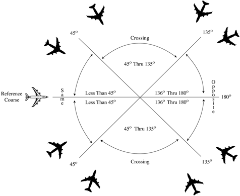
NOTE: The term “protected airspace,” as used in this paragraph, is the airspace equal to one half the required applicable lateral separation on either side of an aircraft along its projected flight path. If the protected airspace of two aircraft does not overlap, applicable lateral separation is ensured.
- SAME COURSES are courses whose protected airspaces are coincident, overlap, or intersect and whose angular difference is less than 45 degrees. (See FIG 1-2-1.)
- CROSSING COURSES are intersecting courses whose angular difference is 45 through 135 degrees inclusive. (See FIG 1-2-1.)
- OPPOSITE/RECIPROCAL COURSES are courses whose protected airspaces are coincident, overlap, or intersect and whose angular difference is greater than 135 degrees through 180 degrees inclusive. (See FIG 1-2-1.)
1-2-3. NOTES
Statements of fact, or of a prefatory or explanatory nature relating to directive material, are set forth as notes.
1-2-4. REFERENCES
As used in this order, references direct attention to an additional or supporting source of information such as FAA, NWS, and other agencies' orders, directives, notices, CFRs, and Advisory Circulars (ACs).
1-2-5. ANNOTATIONS
Revised, reprinted, or new pages are marked as follows:
- The change number and the effective date are printed on each revised or additional page.
- A page that does not require a change is reprinted in its original form.
- Bold vertical lines in the margin of changed pages indicate the location of substantive revisions to the order. Bold vertical lines adjacent to the title of a chapter, section, or paragraph means that extensive changes have been made to that chapter, section, or paragraph.
- Paragraphs/sections annotated with EN ROUTE, OCEANIC, or TERMINAL are only to be applied by the designated type facility. When they are not so designated, the paragraphs/sections apply to all types of facilities (en route, oceanic, and terminal).
- The annotation, USAF for the U.S. Air Force, USN for the U.S. Navy, and USA for the U.S. Army denotes that the procedure immediately following the annotation applies only to the designated service.
- WAKE TURBULENCE APPLICATION inserted within a paragraph means that the remaining information in the paragraph requires the application of wake turbulence procedures.
- The annotation PHRASEOLOGY denotes the prescribed words and/or phrases to be used in communications.
NOTE: Controllers may, after first using the prescribed phraseology for a specific procedure, rephrase the message to ensure the content is understood. Good judgment must be exercised when using nonstandard phraseology.
- The annotation EXAMPLE provides a sample of the way the prescribed phraseology associated with the preceding paragraph(s) will be used. If the preceding paragraph(s) does (do) not include specific prescribed phraseology, the EXAMPLE merely denotes suggested words and/or phrases that may be used in communications.
NOTE: The use of the exact text contained in an example not preceded with specific prescribed phraseology is not mandatory. However, the words and/or phrases are expected, to the extent practical, to approximate those used in the example.
1-2-6. ABBREVIATIONS
As used in this order, the abbreviations listed below have the following meanings indicated. (See TBL 1-2-1.)
| Abbreviation | Meaning |
|---|---|
| AAR | Adapted arrival route |
| AAR | Airport acceptance rate |
| AC | Advisory Circular |
| ACC | Area Control Center |
| ACE-IDS | ASOS Controller Equipment- Information Display System |
| ACL | Aircraft list |
| ACLS | Automatic Carrier Landing System |
| ADAR | Adapted departure arrival route |
| ADC | Aerospace Defense Command |
| ADIZ | Air Defense Identification Zone (to be pronounced “AY DIZ”) |
| ADR | Adapted departure route |
| ADS | Automatic Dependent Surveillance |
| ADS-B | Automatic Dependent Surveillance-Broadcast |
| ADS-C | Automatic Dependent Surveillance-Contract |
| AFP | Airspace flow program |
| AERT | Automation Embedded Route Text |
| AFP | Airspace Flow Program |
| AIDC | ATS Interfacility Data Communications |
| AIM | Aeronautical Information Manual |
| AIRMET | Airmen's meteorological information |
| ALDARS | Automated Lightning Detection and Reporting System |
| ALERFA | Alert phase code (Alerting Service) |
| ALNOT | Alert notice |
| ALS | Approach Light System |
| ALTRV | Altitude reservation |
| AM | Ambiguity- A disparity greater than a locally adapted distance exists between the position declared for a target by MEARTS and another facility's computer declared position during interfacility handoff |
| AMASS | Airport Movement Area Safety System |
| AMB | Ambiguity- A disparity greater than a locally adapted distance exists between the position declared for a target by MEARTS and another facility's computer declared position during interfacility handoff |
| AMVER | Automated Mutual Assistance Vessel Rescue System |
| ANG | Air National Guard |
| APR | ATC preferred route |
| APREQ | Approval Request |
| ARAC | Army Radar Approach Control Facility (US Army) |
| ARINC | Aeronautical Radio Incorporated |
| ARIP | Air refueling initial point |
| ARSR | Air route surveillance radar |
| ARTCC | Air Route Traffic Control Center |
| ASD | Aircraft Situation Display |
| ASDE | Airport Surface Detection Equipment |
| ASDE-X | Airport Surface Detection Equipment System - Model X |
| ASF | Airport Stream Filters |
| ASOS | Automated Surface Observing System |
| ASR | Airport surveillance radar |
| ATC | Air traffic control |
| ATCAA | ATC assigned airspace |
| ATCSCC | David J. Hurley Air Traffic Control System Command Center |
| ATD | Along-Track Distance |
| ATIS | Automatic Terminal Information Service |
| ATO | Air Traffic Organization |
| ATO COO | Air Traffic Organization Chief Operating Officer |
| ATOP | Advanced Technologies and Oceanic Procedures |
| ATS | Air Traffic Service |
| AWOS | Automated Weather Observing System |
| BASE | Cloud base |
| CA | Conflict Alert |
| CARCAH | Chief, Aerial Reconnaissance Coordination, All Hurricanes |
| CARF | Central Altitude Reservation Function |
| CAT | Clear air turbulence |
| CDT | Controlled departure time |
| CEP | Central East Pacific |
| CERAP | Combined Center/RAPCON |
| CFR | Code of Federal Regulations |
| CFR | Call for Release |
| CIC | Controller-in-Charge |
| CNS | Continuous |
| CPDLC | Controller Pilot Data Link Communications |
| CPME | Calibration Performance Monitor Equipment |
| CTA | Control Area |
| CTRD | Certified Tower Radar Display |
| CVFP | Charted Visual Flight Procedure |
| CWA | Center Weather Advisory |
| DETRESFA | Distress Phase code (Alerting Service) |
| DH | Decision height |
| DL | Departure List |
| DME | Distance measuring equipment compatible with TACAN |
| DOE | Department of Energy |
| DP | Instrument Departure Procedure |
| DR | Dead reckoning |
| DRT | Diversion recovery tool |
| DSR | Display System Replacement |
| DTAS | Digital Terminal Automation Systems |
| DTM | Digital Terrain Map |
| DVFR | Defense Visual Flight Rules |
| DVRSN | Diversion |
| EA | Electronic Attack |
| EAS | En Route Automation System |
| EDCT | Expect Departure Clearance Time |
| EDST | En Route Decision Support Tool |
| EFC | Expect further clearance |
| EFVS | Enhanced Flight Vision System |
| ELDB | Enhanced Limited Data Block |
| ELP | Emergency Landing Pattern |
| ELT | Emergency locator transmitter |
| EoR | Established on RNP |
| EOS | End Service |
| EOVM | Emergency obstruction video map |
| ERAM | En Route Automation Modernization |
| ERIDS | En Route Information Display System |
| ERT | Embedded route text |
| ETA | Estimated time of arrival |
| FAA | Federal Aviation Administration |
| FAA Order | FAA Order |
| FANS | Future Air Navigation System |
| FDB | FDB |
| FDIO | Flight Data Input/Output |
| FDP | Flight data processing |
| FICON | Field Condition |
| FIR | Flight Information Region |
| FL | Flight level |
| FLIP | Flight Information Publication |
| FLY | Fly or flying |
| FMS | Flight Management System |
| FMSP | Flight Management System Procedure |
| FSM | Flight Schedule Monitor |
| FSS | Flight Service Station |
| GCA | Ground controlled approach |
| GNSS | Global Navigation Satellite System |
| GPD | Graphics Plan Display |
| GPS | Global Positioning System |
| GS | Ground stop |
| HF/RO | High Frequency/Radio Operator |
| HIRL | High intensity runway lights |
| IAFDOF | Inappropriate Altitude for Direction of Flight |
| ICAO | International Civil Aviation Organization |
| IDENT | Aircraft identification |
| IDS | Information Display System |
| IFR | Instrument flight rules |
| IFSS | International Flight Service Station |
| ILS | Instrument Landing System |
| INCERFA | Uncertainty Phase code (Alerting Service) |
| INREQ | Information request |
| INS | Inertial Navigation System |
| IR | IFR military training route |
| IRU | Inertial Reference Unit |
| ISR | Increased Separation Required |
| ITWS | Integrated Terminal Weather System |
| JATO | Jet assisted takeoff |
| LAHSO | Land and Hold Short Operations |
| LOA | Letter of Agreement |
| LLWAS | Low Level Wind Shear Alert System |
| LLWAS NE | Low Level Wind Shear Alert System Network Expansion |
| LLWAS-RS | Low Level Wind Shear Alert System Relocation/Sustainment |
| LLWS | Low Level Wind Shear |
| L/MF | Low/medium frequency |
| LORAN | Long Range Navigation System |
| Mach | Mach number |
| MALS | Medium Intensity Approach Light System |
| MALSR | Medium Approach Light System with runway alignment indicator lights |
| MAP | Missed approach point |
| MARSA | Military authority assumes responsibility for separation of aircraft |
| MCA | Minimum crossing altitude |
| MCI | Mode C Intruder |
| MDA | Minimum descent altitude |
| MDM | Main display monitor |
| MEA | Minimum en route (IFR) altitude |
| MEARTS | Micro En Route Automated Radar Tracking System |
| METAR | Aviation Routine Weather Report |
| MIA | Minimum IFR altitude |
| MIAWS | Medium Intensity Airport Weather System |
| MIRL | Medium intensity runway lights |
| MNPS | Minimum Navigation Performance Specification |
| MNT | Mach Number Technique |
| MOA | Military operations area |
| MOCA | Minimum obstruction clearance altitude |
| MRA | Minimum reception altitude |
| MSAW | Minimum Safe Altitude Warning |
| MSL | Mean sea level |
| MTI | Moving target indicator |
| MTR | Military training route |
| MVA | Minimum vectoring altitude |
| NADIN | National Airspace Data Interchange Network |
| NAR | National Automation Request |
| NAS | National Airspace System |
| NAT | ICAO North Atlantic Region |
| NAT HLA | North Atlantic High Level Airspace |
| NBCAP | National Beacon Code Allocation Plan |
| NDB | Nondirectional radio beacon |
| NHOP | National Hurricane Operations Plan |
| NM | Nautical mile |
| NOAA | National Oceanic and Atmospheric Administration |
| NOPAC | North Pacific |
| NORAD | North American Aerospace Defense Command |
| NOS | National Ocean Service |
| NOTAM | Notice to Air Missions |
| NOWGT | No weight. The weight class or wake category has not been determined |
| NRP | North American Route Program |
| NRR | Nonrestrictive Route |
| NRS | Navigation Reference System |
| NTZ | No transgression zone |
| NWS | National Weather Service |
| NWSOP | National Winter Storm Operations Plan |
| ODALS | Omnidirectional Approach Lighting System |
| ODP | Obstacle Departure Procedure |
| OID | Operator Interface Device |
| OS | Operations Supervisor |
| OTR | Oceanic transition route |
| PAPI | Precision Approach Path Indicators |
| PAR | Precision approach radar |
| PBCT | Proposed boundary crossing time |
| P/CG | Pilot/Controller Glossary |
| PDC | Pre-Departure Clearance |
| PIREP | Pilot Weather Report |
| PPI | Plan position indicator |
| PTP | Point-to-point |
| PVD | Plan view display |
| RA | Radar Associate |
| RAIL | Runway alignment indicator lights |
| RAPCON | Radar Approach Control Facility (USAF, USN, and USMC) |
| RATCF | Radar Air Traffic Control Facility (USN and USMC) |
| RBS | Radar bomb scoring |
| RCC | Rescue Coordination Center |
| RCLS | Runway Centerline System |
| RCR | Runway condition reading |
| RE | Recent (used to qualify weather phenomena such as rain, e.g. recent rain = RERA) |
| REIL | Runway end identifier lights |
| RF | Radius-to-Fix |
| RNAV | Area navigation |
| RNP | Required Navigation Performance |
| RTQC | Real-Time Quality Control |
| RVR | Runway visual range |
| RVSM | Reduced Vertical Separation Minimum |
| RwyCC | Runway Condition Codes |
| RwyCR | Runway Condition Report |
| SAA | Special Activity Airspace |
| SAR | Search and rescue |
| SATCOM | Satellite Communication |
| SDP | Surveillance Data Processing |
| SELCAL | Selective Calling System |
| SFA | Single frequency approach |
| SFO | Simulated flameout |
| SID | Standard Instrument Departure |
| SIGMET | Significant meteorological information |
| SPA | Special Posting Area |
| SPECI | Nonroutine (Special) Aviation Weather Report |
| STAR | Standard terminal arrival |
| STARS | Standard Terminal Automation Replacement System |
| STMC | Supervisory Traffic Management Coordinator |
| STMCIC | Supervisory Traffic Management Coordinator-in-charge |
| STOL | Short takeoff and landing |
| SURPIC | Surface Picture |
| SVFR | Special Visual Flight Rules |
| TAA | Terminal arrival area |
| TAS | Terminal Automation Systems |
| TACAN | TACAN UHF navigational aid (omnidirectional course and distance information) |
| TAWS | Terrain Awareness Warning System |
| TCAS | Traffic Alert and Collision Avoidance System |
| TCDD | Tower cab digital display |
| TDLS | Terminal Data Link System |
| TDW | Tower display workstation |
| TDWR | Terminal Doppler Weather Radar |
| TDZL | Touchdown Zone Light System |
| TF | Track-to-Fix |
| TFMS | Traffic Flow Management System |
| TMC | Traffic Management Coordinator |
| TMU | Traffic Management Unit |
| TRACON | Terminal Radar Approach Control |
| TRSA | Terminal radar service area |
| UFO | Unidentified flying object |
| UHF | Ultra high frequency |
| USA | United States Army |
| USAF | United States Air Force |
| USN | United States Navy |
| UTC | Coordinated universal time |
| UTM | Unsuccessful transmission message |
| UUA | Urgent pilot weather report |
| VCI | Voice Communication Indicator |
| VFR | Visual flight rules |
| VHF | Very high frequency |
| VMC | Visual meteorological conditions |
| VNAV | Vertical Navigation |
| VOR | VHF navigational aid (omnidirectional course information) |
| VOR/DME | Collocated VOR and DME navigational aids (VHF course and UHF distance information) |
| VORTAC | Collocated VOR and TACAN navigation aids (VHF and UHF course and UHF distance information) |
| VR | VFR military training route |
| VSCS | Voice Switching and Control System |
| WAAS | Wide Area Augmentation System |
| WARP | Weather and Radar Processing |
| WATRS | West Atlantic Route System |
| WRA | Weather Reconnaissance Area |
| WSO | Weather Service Office |
| WSP | Weather System Processor |
| WST | Convective SIGMET |