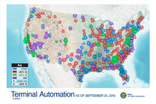
I use this map to see where various different approach control airspaces are in the country:

There are various versions of it you can find online, some more recent than others, and they seem to be updated as consolidations and moves happen. This one from the NATCA website shows newly-delegated approach airspace at Johnstown, PA.
I'm curious about Cheyenne Approach, which is not shown on this map or any version of it I've seen. CYS tower is operated by the National Guard; I would imagine the appraoch is as well. Why is it not depicted? Are there any other "hidden" approach controls that people know about?