Section 5. Altitude Assignment and Verification
- Views Views: 2,285
- Last updated Last updated:
-
Sub-pages:
Section 5. Altitude Assignment and Verification
4-5-1. VERTICAL SEPARATION MINIMA
Separate instrument flight rules (IFR) aircraft using the following minima between altitudes:
- Up to and including FL 410- 1,000 feet.
- Apply 2,000 feet at or above FL 290 between non-RVSM aircraft and all other aircraft at or above FL 290.
-
Above FL 410- 2,000 feet, except:
- In oceanic airspace, above FL 450 between a supersonic and any other aircraft- 4,000 feet.
- Above FL 600 between military aircraft- 5,000 feet.
Oceanic separation procedures are supplemented in Chapter 8; Section 7, Section 8, Section 9 , and Section 10.
4-5-2. FLIGHT DIRECTION
Clear aircraft at altitudes according to the TBL 4-5-1.
TBL 4-5-1 Altitude Assignment Aircraft Operating On course degrees magnetic Assign Examples Below 3,000 feet above surface Any course Any altitude At and below FL 410 0 through 179 Odd cardinal altitude or flight levels at intervals of 2,000 feet - 3,000,
- 5,000,
- FL 310,
- FL 330
180 through 359 Even cardinal altitude or flight levels at intervals of 2,000 feet - 4,000,
- 6,000,
- FL 320,
- FL 340
Above FL 410 0 through 179 Odd cardinal flight levels at intervals of 4,000 feet beginning with FL 450 - FL 450,
- FL 490,
- FL 530
180 through 359 Odd cardinal flight levels at intervals of 4,000 feet beginning with FL 430 - FL 430,
- FL 470,
- FL 510
One way routes (except in composite systems) Any course Any cardinal altitude or flight level below FL 410 or any odd cardinal flight level above FL 410 - FL 270,
- FL 280,
- FL 290,
- FL 300,
- FL 310,
- FL 410,
- FL 430,
- FL 450
Within an ALTRV Any course Any altitude or flight level In aerial refueling tracks and anchors Any course Altitude blocks as requested. Any altitude or flight level - 050B080,
- FL 180B220,
- FL 280B310
In aerial refueling tracks and anchors Any course Altitude blocks as requested. Any altitude or flight level - 050B080,
- FL 180B220,
- FL 280B310
4-5-3. EXCEPTIONS
When traffic, meteorological conditions, or aircraft operational limitations prevent assignment of altitudes prescribed in paragraph 4-5-2, Flight Direction, assign any cardinal altitude or flight level below FL 410 or any odd cardinal flight level at or above FL 410 without regard to direction of flight as follows:
NOTE: See paragraph 2-3-10, Control Symbology, for control abbreviations and symbols to be used in conjunction with this paragraph.
- For traffic conditions, take this action only if one of the following conditions exists:
- Aircraft remain within a facility's area and prior approval is obtained from other affected positions or sectors or the operations are covered in a Facility Directive.
- Aircraft will proceed beyond the facility's area and specific operations and procedures permitting random altitude assignment are covered in a letter of agreement between the appropriate facilities.
- Military aircraft are operating on random routes and prior approval is obtained from the facility concerned.
- For meteorological conditions, take this action only if you obtain prior approval from other affected positions or sectors within your facility and, if necessary, from the adjacent facility concerned.
- For aircraft operational limitations, take this action only if the pilot informs you the available appropriate altitude exceeds the operational limitations of his/her aircraft and only after you obtain prior approval from other affected positions or sectors within your facility and, if necessary, from the adjacent facility concerned.
- For mission requirements, take this action only when the aircraft is operating on an MTR.
4-5-4. LOWEST USABLE FLIGHT LEVEL
If a change in atmospheric pressure affects a usable flight level in your area of jurisdiction, use TBL 4-5-2 to determine the lowest usable flight level to clear aircraft at or above 18,000 feet MSL.
TBL 4-5-2 Lowest Usable FL Altimeter Setting Lowest Usable FL 29.92” or higher 180 29.91” to 28.92” 190 28.91” to 27.92” 200 4-5-5. ADJUSTED MINIMUM FLIGHT LEVEL
When the prescribed minimum altitude for IFR operations is at or above 18,000 feet MSL and the atmospheric pressure is less than 29.92”, add the appropriate adjustment factor from TBL 4-5-3 to the flight level equivalent of the minimum altitude in feet to determine the adjusted minimum flight level.
TBL 4-5-3 Minimum FL Adjustment Altimeter Setting Adjustment Factor 29.92” or higher None 29.91” to 29.42” 500 feet 29.41” to 28.92” 1000 feet 28.91” to 28.42” 1500 feet 28.41” to 27.92” 2000 feet 4-5-6. MINIMUM ENROUTE ALTITUDES
Except as provided in subparas a and b below, assign altitudes at or above the MEA for the route segment being flown. When a lower MEA for subsequent segments of the route is applicable, issue the lower MEA only after the aircraft is over or past the Fix/NAVAID beyond which the lower MEA applies unless a crossing restriction at or above the higher MEA is issued.
- An aircraft may be cleared below the MEA but not below the MOCA for the route segment being flown if the
altitude assigned is at least 300 feet above the floor of controlled airspace and one of the following conditions
is met:
NOTE: Controllers must be aware that in the event of radio communications or GNSS failure, a pilot will climb to the MEA for the route segment being flown.
- For aircraft using VOR, VORTAC or TACAN for navigation, this applies only within 22 miles of that NAVAID.
- When radar procedures are used, the following actions are taken:
- (a) In the absence of a published MOCA, assign altitudes at or above the MVA or MIA along the route of flight, and
- (b) Lost communications instructions are issued.
- The aircraft is GNSS equipped.
- An aircraft may be cleared to operate on jet routes below the MEA (but not below the prescribed minimum altitude
for IFR operations) or above the maximum authorized altitude if, in either case, radar service is provided.
NOTE: Minimum en route and maximum authorized altitudes for certain jet route segments have been established above the floor of the jet route structure due to limitations on navigational signal coverage.
- Where a higher altitude is required because of an MEA, the aircraft must be cleared to begin climb to the higher
MEA as follows:
- If no MCA is specified, prior to or immediately after passing the fix where the higher MEA is designated.
(See FIG 4-5-1.)
FIG 4-5-1 No MCA Specified 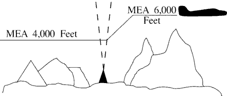
- If a MCA is specified, prior to the fix so as to cross the fix at or above the MCA. (See FIG 4-5-2.)
FIG 4-5-2 MCA Specified 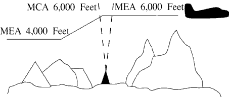
- If no MCA is specified, prior to or immediately after passing the fix where the higher MEA is designated.
(See FIG 4-5-1.)
- GNSS MEAs may be approved on published ATS routes. Air traffic may assign GNSS MEAs to GNSS-equipped aircraft
where established.
NOTE: On high altitude ATS routes, the GNSS MEA is FL180 unless published higher.
- Where MEAs have not been established, clear an aircraft at or above the minimum altitude for IFR operations prescribed by 14 CFR Section 91.177.
4-5-7. ALTITUDE INFORMATION
interpretation 11Issue altitude instructions as follows:
- Altitude to maintain or cruise. When issuing cruise in conjunction with an airport clearance limit and an unpublished route will be used, issue an appropriate crossing altitude to ensure terrain clearance until the aircraft reaches a fix, point, or route where the altitude information is available to the pilot. When issuing a cruise clearance to an airport which does not have a published instrument approach, a cruise clearance without a crossing restriction may be issued.
- PHRASEOLOGY
- MAINTAIN/CRUISE (altitude). MAINTAIN (altitude) UNTIL (time, fix, waypoint),
- or
- (number of miles or minutes) MILES/MINUTES PAST (fix, waypoint).
- CROSS (fix, point, waypoint),
- or
- INTERCEPT (route) AT OR ABOVE (altitude), CRUISE (altitude).
- NOTE:
- 1. The crossing altitude must assure IFR obstruction clearance to the point where the aircraft is established on a segment of a published route or instrument approach procedure.
- 2. When an aircraft is issued a cruise clearance to an airport which does not have a published instrument approach procedure, it is not possible to satisfy the requirement for a crossing altitude that will ensure terrain clearance until the aircraft reaches a fix, point, or route where altitude information is available to the pilot. Under those conditions, a cruise clearance without a crossing restriction authorizes a pilot to determine the minimum IFR altitude as prescribed in 14 CFR Section 91.177 and descend to it at pilot discretion if it is lower than the altitude specified in the cruise clearance.
- Instructions to climb or descend including restrictions, as required. Specify a time restriction reference the UTC clock reading with a time check. If you are relaying through an authorized communications provider, such as New York Radio or San Francisco Radio, FSS, etc., advise the radio operator to issue the current time to the aircraft when the clearance is relayed. The requirement to issue a time check must be disregarded if the clearance is issued via Controller Pilot Data Link Communications (CPDLC).
EXCEPTION. If you are in direct, two-way, VHF/UHF voice communication with the pilot and the aircraft is in radar contact, you may specify an elapsed time interval restriction, in full minute increments only, without any reference to the UTC clock. The time restriction begins once the clearance has been acknowledged by the pilot.
- EXAMPLE
- 1. “United Four Seventeen, climb to reach one three thousand at two two one five.”
“Time two two one one and one-quarter.”
The pilot is expected to be level at 13,000 feet at 2215 UTC.
- 2. Through Relay - “Speedbird Five, climb to reach flight level three-five zero at one-two-one-five, time” (Issue a time check).
- 3. In radar contact and in direct controller to pilot, two-way, VHF/UHF voice communication - “United Four Seventeen, descend to reach flight level three five zero within two minutes.” The time restriction begins once the clearance has been acknowledged by the pilot.
- 4. “United Four Seventeen climb to leave flight level three three zero within two minutes, maintain flight level three five zero.”
- REFERENCE
- FAA Order JO 7110.65, Para 1-2-1, Word Meanings.
- FAA Order JO 7110.65, Para 2-4-17, Numbers Usage.
- PHRASEOLOGY
- CLIMB/DESCEND AND MAINTAIN (altitude). If required,
- AFTER PASSING (fix, waypoint), or
- AT (time) (time in hours, minutes, and nearest quarter minute).
- CLIMB/DESCEND TO REACH (altitude) AT (time (issue time check) or fix, waypoint),
- or
- AT (time). CLIMB/DESCEND AND MAINTAIN (altitude) WHEN ESTABLISHED AT LEAST (number of miles or minutes) MILES/MINUTES PAST (fix, waypoint) ON THE (NAVAID) (specified) RADIAL.
- CLIMB/DESCEND TO REACH (altitude) AT (time or fix, waypoint),
- or
- A POINT (number of miles) MILES (direction) OF (name of DME NAVAID),
- or
- MAINTAIN (altitude) UNTIL (time (issue time check), fix, waypoint), THEN CLIMB/DESCEND AND MAINTAIN (altitude).
- Through relay:
- CLIMB TO REACH (altitude) AT (time) (issue a time check).
- Or
- Using a time interval while in radar contact and in direct controller to pilot, two-way, VHF/UHF voice communication:
- CLIMB/DESCEND TO REACH/LEAVE (altitude) WITHIN (number) MINUTES, MAINTAIN (altitude).
- Or
- CLIMB/DESCEND TO REACH/LEAVE (altitude) IN (number) MINUTES OR LESS, MAINTAIN (altitude).
- Specified altitude for crossing a specified fix or waypoint; or, specified altitude for crossing a distance (in miles) and direction from a specified fix or waypoint.
- PHRASEOLOGY
- CROSS (fix, waypoint) AT (altitude).
- CROSS (fix, waypoint) AT OR ABOVE/BELOW (altitude). CROSS (number of miles) MILES (direction) OF (name of fix, waypoint) AT (altitude).
- CROSS (number of miles) MILES (direction) OF (name of fix, waypoint) AT OR ABOVE/BELOW (altitude).
- A specified altitude over a specified fix for that portion of a descent clearance where descent at pilot's discretion is permissible. At any other time it is practicable, authorize climb/descent at pilot's discretion.
- PHRASEOLOGY
- CLIMB/DESCEND AT PILOT'S DISCRETION.
- EXAMPLE
- “United Four Seventeen, descend and maintain six thousand.”
NOTE: The pilot is expected to commence descent upon receipt of the clearance and to descend at the suggested rates specified in the AIM, para 4-4-10, Adherence to Clearance, until reaching the assigned altitude of 6,000 feet.
- EXAMPLE
- “United Four Seventeen, descend at pilot's discretion, maintain six thousand.”
NOTE: The pilot is authorized to conduct descent within the context of the term “at pilot's discretion” as described in the AIM.
- EXAMPLE
- “United Four Seventeen cross Lakeview V-O-R at or above flight level two zero zero, descend and maintain six thousand.”
NOTE: The pilot is authorized to conduct descent “at pilot's discretion” until reaching Lakeview VOR. The pilot must comply with the clearance provision to cross the Lakeview VOR at or above FL 200, and after passing Lakeview VOR, the pilot is expected to descend at the rates specified in the AIM until reaching the assigned altitude of 6,000 feet.
- EXAMPLE
- “United Four Seventeen, cross Lakeview V-O-R at and maintain six thousand.”
NOTE: The pilot is authorized to conduct descent “at pilot's discretion,” but must comply with the clearance provision to cross Lakeview VOR at 6,000 feet.
- EXAMPLE
- “United Four Seventeen, descend now to flight level two seven zero, cross Lakeview V-O-R at or below one zero thousand, descend and maintain six thousand.”
NOTE: The pilot is expected to promptly execute and complete descent to FL 270 upon receipt of the clearance. After reaching FL 270, the pilot is authorized to descend “at pilot's discretion” until reaching Lakeview VOR. The pilot must comply with the clearance provision to cross Lakeview VOR at or below 10,000 feet. After Lakeview VOR, the pilot is expected to descend at the rates specified in the AIM until reaching 6,000 feet.
- NOTE:
- 1. A descent clearance which specifies a crossing altitude authorizes descent at pilot's discretion for that portion of the flight to which the crossing altitude restriction applies.
- 2. Any other time that authorization to descend at pilot's discretion is intended, it must be specifically stated by the controller.
- 3. The pilot may need to know of any future restrictions that might affect the descent, including those that may be issued in another sector, in order to properly plan a descent at pilot's discretion.
- 4. Controllers need to be aware that the descent rates in the AIM are only suggested and aircraft will not always descend at those rates.
- REFERENCE
- P/CG, Pilot's Discretion.
- When a portion of a climb/descent may be authorized at the pilot's discretion, specify the altitude the aircraft must climb/descend to followed by the altitude to maintain at the pilot's discretion.
- PHRASEOLOGY
- CLIMB/DESCEND NOW TO (altitude), THEN CLIMB/DESCEND AT PILOT'S DISCRETION MAINTAIN (altitude).
- EXAMPLE
- “United Three Ten, descend now to flight level two eight zero, then descend at pilot's discretion maintain flight level two four zero.”
- NOTE:
- 1. The pilot is expected to commence descent upon receipt of the clearance and to descend as prescribed in the AIM, para 4-4-10, Adherence to Clearance, until FL 280. At that point, the pilot is authorized to continue descent to FL 240 within context of the term “at pilot's discretion” as described in the AIM.
- 2. Controllers need to be aware that the descent rates are only suggested and aircraft will not always descend at those rates.
- When the “pilot's discretion” portion of a climb/descent clearance is being canceled by assigning a new altitude, inform the pilot that the new altitude is an “amended altitude.”
- EXAMPLE
- “American Eighty Three, amend altitude, descend and maintain Flight Level two six zero.”
NOTE: American Eighty Three, at FL 280, has been cleared to descend at pilot's discretion to FL 240. Subsequently, the altitude assignment is changed to FL 260. Therefore, pilot's discretion is no longer authorized.
- Altitude assignments involving more than one altitude.
- PHRASEOLOGY
- MAINTAIN BLOCK (altitude) THROUGH (altitude).
- Instructions to vertically navigate SIDs/STARs with published crossing restrictions (Climb Via/Descend Via).
- When established on the SID/STAR.
- When navigating a published route inbound to the STAR.
- When cleared direct to a waypoint/fix without a published altitude, assign a crossing altitude.
- PHRASEOLOGY
- DESCEND VIA (STAR name and number).
- DESCEND VIA (STAR name and number and runway transition number)
- DESCEND VIA (STAR name and number and runway number).
- CLIMB VIA (SID name and number).
- PROCEED DIRECT (fix/waypoint), CROSS (waypoint/fix) at (altitude) THEN DESCEND VIA (STAR name and number)
- EXAMPLE
- “Descend via the Eagul Five arrival.”
- “Descend via the Wynde Eight Arrival, Runway 28 right transition.”
- “Descend via the Lendy One Arrival, Runway 22 left.”
- “Climb via the Dawgs Four Departure.”
- “Proceed direct Denis, cross Denis at or above flight level two zero zero, then descend via the Mmell One arrival.”
- NOTE: Pilots must comply with all published speed restrictions on SIDs/STARs, independent of a climb via or descend via clearance.
- Clearance to “descent via” authorizes pilots:
- 1. To descend at pilot discretion to meet published restrictions on a STAR. Pilots navigating on a STAR must maintain the last assigned altitude until receiving clearance to descend via. Once leaving an altitude, the pilot may not return to that altitude without an ATC clearance.
- 2. When cleared direct to a waypoint, to descend at pilot discretion to meet restrictions on the procedure. ATC assumes obstacle clearance responsibility for aircraft not yet established or taken off of a procedure.
- 3. To adjust speeds prior to reaching waypoints with published speed restrictions.
- NOTE: When cleared for SIDs that contain published speed restrictions, the pilot must comply with those speed restrictions independent of any “climb via” clearance. Clearance to “climb via” authorizes pilots:
- 1. When used in the IFR departure clearance, in a PDC, DCL or when subsequently cleared after departure to a waypoint depicted on a SID, to join a procedure after departure or resume a procedure.
- 2. When vertical navigation is interrupted and an altitude is assigned to maintain which is not contained on the published procedure, to climb from that previously-as- signed altitude at pilot's discretion to the altitude depicted for the next waypoint. ATC must ensure obstacle clearance until the aircraft is established on the lateral and vertical path of the SID.
- 3. Once established on the depicted departure, to climb and to meet all published or assigned altitude and speed restrictions.
- REFERENCE
- FAA Order JO 7110.65, Para 4-4-2, Route Structure Transitions.
- FAA Order JO 7110.65, Para 4-5-6, Minimum En Route Altitudes.
- FAA Order JO 7110.65, Para 5-5-9, Separation From Obstructions.
- P/CG, Climb Via, Descend Via.
NOTE: Pilots cleared for vertical navigation using the phraseology “descend via” or “climb via” must inform ATC, upon initial contact, of the altitude leaving, the runway transition or landing direction if assigned (STARs), and any assigned restrictions not published on the procedure.
- EXAMPLE
- “Delta One Twenty One leaving flight level one niner zero, descending via the Eagul Five arrival runway two-six transition.”
- “Delta One Twenty One leaving flight level one niner zero for one two thousand, descending via the Eagul Five arrival, runway two-six transition.”
- “JetBlue six zero two leaving flight level two one zero descending via the Ivane Two arrival landing south.”
- “Cactus Seven Eleven leaving two thousand climbing via the Laura Two departure.”
- “Cactus Seven Eleven leaving two thousand for one-six thousand, climbing via the Laura Two departure.”
- REFERENCE
- AIM, Para 5-2-8, Instrument Departure Procedures (DP) - Obstacle Departure Procedures (ODP) and Standard Instrument Departures (SID).
- P/CG, Top Altitude, Bottom Altitude.
- AIM, Para 5-4-1, Standard Terminal Arrival (STAR) Procedures.
- A “descend via” clearance must not be used where procedures contain only published “expect” altitude and/or speed restrictions.
NOTE: Pilots are not expected to comply with published “expect” restrictions in the event of lost communications, unless ATC has specifically advised the pilot to expect these restrictions as part of a further clearance.
- “Descend via” may be used on procedures that contain both “expect” and required altitude and speed restrictions only if altitude and/or speed restrictions or alternate restrictions are issued for the fix/waypoint associated with all expect restrictions.
- “Descend via” clearances may also be issued if an aircraft is past all fixes/waypoints that have expect restrictions.
- If it is necessary to assign a crossing altitude which differs from the STAR or SID altitude, emphasize the change to the pilot.
- PHRASEOLOGY
- DESCEND VIA (STAR name and number) ARRIVAL, EXCEPT CROSS (fix, point, waypoint), (revised altitude information).
- EXAMPLE
- “United 454 descend via the Haris One Arrival, except cross Haris at or above one six thousand.”
NOTE: The aircraft should track laterally and vertically on the Haris One Arrival and should descend so as to cross Haris at or above 16,000; remainder of the arrival must be flown as published.
- PHRASEOLOGY
- CLIMB VIA SID, EXCEPT CROSS (fix, point, waypoint), (revised altitude information).
- CLIMB VIA (SID name and number), EXCEPT CROSS (fix, point, waypoint), (revised altitude information).
- EXAMPLE
- 1. “Climb via SID except cross Mkala at or above seven thousand.”
NOTE: In Example 1, the aircraft will comply with the assigned SID departure lateral path and any published speed and altitude restrictions and climb so as to cross Mkala at or above 7,000; remainder of the departure must be flown as published.
- EXAMPLE
- 2. (There is a published altitude at Dvine WP): “Proceed direct Dvine, Climb via the Suzan Two departure except cross Mkala at or above seven thousand.”
NOTE: In Example 2, the aircraft will join the Suzan Two departure at Dvine, at the published altitude, and then comply with the published lateral path and any published speed or altitude restrictions. The aircraft will climb so as to cross Mkala at or above 7,000; remainder of the departure must be flown as published.
- When an aircraft has been issued an interim altitude and after departure ATC can subsequently clear the aircraft to climb to the original top altitude published in a SID that contains published crossing restrictions, instruct aircraft to “climb via SID.” When issuing a different altitude and compliance with published restrictions is still required, instruct aircraft to “climb via SID except maintain (altitude).”
- PHRASEOLOGY
- CLIMB VIA SID.
- CLIMB VIA SID except maintain (altitude).
- EXAMPLE
- 1. (An aircraft was issued the Teddd One departure, “climb via SID” in the IFR departure clearance. An interim altitude of 10,000 was issued instead of the published top altitude of FL 230; after departure ATC is able to issue the published top altitude): “Climb via SID.”
NOTE: In Example 1, the aircraft will track laterally and vertically on the Teddd One departure and initially climb to 10,000; Once re-issued the “climb via” clearance the interim altitude is canceled aircraft will continue climb to FL230 while complying with published restrictions.
- EXAMPLE
- 2. (Using Example 1, after departure ATC is able to issue an altitude higher than the published top altitude): “Climb via SID except maintain flight level two six zero.”
NOTE: In Example 2, the aircraft will track laterally and vertically on the Teddd One departure and initially climb to 10,000; once issued “climb via” clearance to FL260 the aircraft will continue climb while complying with published restrictions.
- If it is necessary to assign an interim altitude or assign a bottom or top altitude not contained on a STAR or SID, the provisions of subparagraph 4-5-7h may be used in conjunction with subparagraph 4-5-7a.
- PHRASEOLOGY
- DESCEND VIA THE (STAR name and number) ARRIVAL EXCEPT AFTER (fix) MAINTAIN (revised altitude information).
- EXAMPLE
- “United 454 descend via the Eagul Five Arrival, except after Geeno maintain one zero thousand.”
NOTE: The aircraft should track laterally and vertically on the Eagul Five Arrival and should descend so as to comply with all speed and altitude restrictions until reaching Geeno and then maintain 10,000. Upon reaching 10,000, aircraft should maintain 10,000 until cleared by ATC to continue to descend.
- REFERENCE
- FAA Order JO 7110.65, Para 4-7-1, Clearance Information.
- AIM, Para 5-4-1, Standard Terminal Arrival (STAR) Procedures.
- PHRASEOLOGY
- CLIMB VIA SID EXCEPT AFTER (waypoint name), MAINTAIN (altitude).
- EXAMPLE
- “Climb via SID except after Baret, maintain flight level one niner zero.”
- NOTE:
- 1. Considering the principle that the last ATC clearance issued has precedence over the previous, the phraseology “maintain (altitude)” alone cancels previously issued altitude restrictions, including SID/STAR altitude restrictions unless they are restated or modified, and authorizes an unrestricted climb or descent. Speed restrictions remain in effect unless the controller explicitly cancels the speed restrictions.
- 2. Restate “climb/descend via” and then use “except” or “except maintain” phraseology to modify published restrictions or assign a new top/bottom altitude. Use “resume” phraseology with “maintain” to rejoin a route and assign a new altitude where compliance with published altitude restrictions is not required.
- When a pilot is unable to accept a clearance, issue revised instructions to ensure positive control and approved separation.
- NOTE:
- 1. 14 CFR Section 91.123 states that a pilot is not allowed to deviate from an ATC clearance “that has been obtained...unless an amended clearance is obtained” (except when an emergency exists).
- 2. A pilot is therefore expected to advise the controller if a clearance cannot be accepted when the clearance is issued. “We will try” and other such acknowledgments do not constitute pilot acceptance of an ATC clearance.
- 3. Controllers are expected to issue ATC clearances which conform with normal aircraft operational capabilities and do not require “last minute” amendments to ensure approved separation.
- 4. “Expedite” is not to be used in lieu of appropriate restrictions to ensure separation.
4-5-8. ANTICIPATED ALTITUDE CHANGES
If practicable, inform an aircraft when to expect climb or descent clearance or to request altitude change from another facility.
- PHRASEOLOGY
- EXPECT HIGHER/LOWER IN (number of miles or minutes) MILES/MINUTES,
- or
- AT (fix). REQUEST ALTITUDE/FLIGHT LEVEL CHANGE FROM (name of facility).
- If required,
- AT (time, fix, or altitude).
4-5-9. ALTITUDE CONFIRMATION - NONRADAR
- Request a pilot to confirm assigned altitude on initial contact and when position reports are received unless:
NOTE: For the purpose of this paragraph, “initial contact” means a pilot's first radio contact with each sector/position.
- The pilot states the assigned altitude, or
- You assign a new altitude to a climbing or descending aircraft, or
- TERMINAL. The aircraft was transferred to you from another sector/position within your facility (intrafacility).
- PHRASEOLOGY
- (In level flight situations),
- VERIFY AT (altitude/flight level).
- (In climbing/descending situations),
- (if aircraft has been assigned an altitude below the lowest usable flight level),
- VERIFY ASSIGNED ALTITUDE (altitude).
- (If aircraft has been assigned a flight level at or above the lowest usable flight level),
- VERIFY ASSIGNED FLIGHT LEVEL (flight level).
- USA. Reconfirm all pilot altitude read backs.
- PHRASEOLOGY
- (If altitude read back is correct), AFFIRMATIVE (altitude).
- (If altitude read back is not correct),
- NEGATIVE. CLIMB/DESCEND AND MAINTAIN (altitude),
- or
- NEGATIVE. MAINTAIN (altitude).