Section 1. General
9-1-1. GENERAL
Provide aircraft engaged in the flight inspection of NAVAIDs with maximum assistance. Unless otherwise agreed to, maintain direct contact with the pilot and exchange information regarding known traffic in the area and his/her intentions.
- NOTE:
- 1. Many flight inspections are accomplished using automatic recording equipment, and an uninterrupted flight is necessary for successful completion of the mission. The workload for the limited number of aircraft engaged in these activities requires strict adherence to a schedule.
- 2. Flight inspection operations which require special participation of ground personnel, specific communications, or radar operation capabilities are considered to require special handling. These flights are coordinated with appropriate facilities before departure.
- REFERENCE
- FAA Order 8200.1, United States Standard Flight Inspection Manual.
- FAA Order 8240.41, Flight Inspection/Air Traffic On-Site Coordination Requirements.
9-1-2. SPECIAL HANDLING
- Clear the aircraft according to pilot request as soon as practicable. Do not ask the pilot to deviate from his/her planned action except to preclude an emergency situation.
- REFERENCE
- FAA Order 8240.41, Flight Inspection/Air Traffic On-Site Coordination Requirements, Appendix 1, describes certain flight inspection maneuvers in detail.
- Issue radar advisories to the flight inspection aircraft where adequate coverage exists and to the extent permitted by workload.
- Suggest flight path adjustments, as required, for any aircraft which will enter or penetrate an area in which a flight inspection function is being performed.
- Provide special handling, as required, to FAA aircraft conducting flight inspections using the call sign “Flight Check.” The call sign “Flight Check (Nr) recorded” indicates automated flight inspections are in progress in terminal areas.
- NOTE:
- 1. FAA flight inspection aircraft will file flight plans using the call sign “FLIGHT CHECK” during flight inspections or when inbound to conduct flight inspections. Flight plan remarks may indicate type NAVAID inspection to be accomplished; e.g. “FC OKC P.”
- 2. Authorized non-FAA Service Providers conducting Flight Validation activities use the call sign “FLIGHT VAL.” Although these activities are similar to Flight Inspection activities, no additional priority is granted with this call sign.
9-1-3. FLIGHT CHECK AIRCRAFT
- Provide special handling, as required, to expedite flight inspection of NAVAIDs and RADAR by flight check aircraft.
NOTE: Certain flight inspection maneuvers require operations in close proximity to the surface. These maneuvers can only be performed during daylight visual meteorological conditions. Preplanned automatic flight places the following limitations on the capability of the pilot to adhere to normal ATC clearances:
- Route of flight - orbital from 6 nautical miles to a maximum of 40 nautical miles from the facility depending on the type of inspection. During commissioning flight checks all SIDs, STARs, airways, DME fixes, and approaches must be flown.
- Altitude assignment - from 1,000 feet above the antenna site up to the minimum en route altitude (MEA).
- REFERENCE
- FAA Order JO 7110.65, Para 2-1-4, Operational Priority.
- FAA Order 8240.41, Flight Inspection/Air Traffic On-Site Coordination Requirements, Appendix 1, describes certain flight inspection maneuvers in detail.
- Avoid changes in the route or altitude from that filed by the pilot in the initial flight plan.
- Do not impose air traffic control delays in the flight except to preclude emergency situations.
- Do not change the previously assigned discrete beacon code of special radar accuracy flight check aircraft.
- REFERENCE
- FAA Order JO 7210.3, Para 7-1-2, Special Radar Accuracy Checks.
- FAA Order JO 7210.3, Para 10-5-4, ASR Performance Checks.
Section 2. Special Operations
9-2-1. AIRCRAFT CARRYING DANGEROUS MATERIALS
- Provide the following special handling to military aircraft or military contracted aircraft carrying dangerous materials when:
- The words “dangerous cargo,” or “inert devices,” or both are contained in the remarks section of the filed flight plan, or
- NOTE:
- 1. Certain types of military flights carrying dangerous materials require strict adherence to military regulations and flight planning along carefully selected routes. These flights must avoid heavily populated areas.
- 2. “Inert devices” are devices containing no dangerous materials but closely resembling nuclear or explosive items that are classified as dangerous and could be easily mistaken for their dangerous counterparts.
- The pilot uses these words in radio communication.
- The words “dangerous cargo,” or “inert devices,” or both are contained in the remarks section of the filed flight plan, or
- If it becomes necessary to issue a clearance to amend the route/altitude, advise the pilot:
- Of the proposed change, and
- The amount of delay to expect if it is necessary to maintain the present route/altitude.
- When it becomes necessary for the pilot to refuse a clearance amending his/her route/altitude, he/she will advise if the traffic delay is acceptable or if an alternate route/altitude is desired. In such cases, offer all possible assistance.
- When the aircraft is provided an en route descent, do not vector the aircraft from the planned route unless the pilot concurs.
- Use special patterns and routings in areas where they have been developed for these flights. If special patterns and routings have not been developed, employ normal procedures.
9-2-2. CELESTIAL NAVIGATION TRAINING
EN ROUTE
- Approve flight plans specifying celestial navigation only when it is requested for USAF or USN aircraft.
NOTE: An ATC clearance must be obtained by the pilot before discontinuing conventional navigation to begin celestial navigation training. The pilot will advise when discontinuing celestial navigation and resuming conventional navigation. Celestial navigation training will be conducted within 30 NM of the route centerline specified in the en route clearance unless otherwise authorized by ATC. During celestial navigation training, the pilot will advise ATC before initiating any heading changes which exceed 20 degrees.
- Within conterminous U.S. airspace, limit celestial navigation training to transponder-equipped aircraft within areas of ARTCC radar coverage.
- Prior to control transfer, ensure that the receiving controller is informed of the nature of the celestial navigation training leg.
9-2-3. EXPERIMENTAL AIRCRAFT OPERATIONS
- When notified that an experimental aircraft requires special handling:
NOTE: 14 CFR Section 91.319(d)(3) requires that each person operating an aircraft with an experimental certificate must notify the control tower of the experimental nature of the aircraft when operating into or out of airports with operating control towers.
- Clear the aircraft according to pilot requests as traffic permits and if not contrary to ATC procedures.
- Once approved, do not ask the pilot to deviate from a planned action except to preclude an emergency situation.
- At locations where volume or complexity of experimental aircraft operations warrant, a letter of agreement may be consummated between the facility and operator.
9-2-4. FAA RESEARCH AND DEVELOPMENT FLIGHTS
When coordinated in advance and traffic permits, approve requests for special flight procedures from aircraft participating in FAA research and development test activities. These special procedures must be applied to participating aircraft/vehicles.
NOTE: Special flight procedures for FAA research and development test activities must be approved by the facility air traffic manager prior to their use.
9-2-5. FLYNET
Provide expeditious handling for U.S. Government, civil or military aircraft using the code name “FLYNET.” Relay the code name as an element in the remarks position of the flight plan.
NOTE: The code name “FLYNET” indicates that an aircraft is transporting a nuclear emergency team or a disaster control team to the location of a potential or actual nuclear accident or an accident involving chemical agents or hazardous materials. It is in the public interest that they reach their destination as rapidly as possible.
- REFERENCE
- FAA Order JO 7110.65, Para 2-1-4, Operational Priority.
- FAA Order JO 7610.4, Para 12-4-1, “FLYNET” Flights, Nuclear Emergency Teams.
9-2-6. IFR MILITARY TRAINING ROUTES
-
Except for aircraft operating in the same altitude reservation, clear aircraft into an MTR provided separation
will be applied between successive aircraft unless otherwise covered in a letter of agreement between the military
scheduling activity and the concerned ATC facility.
- PHRASEOLOGY
- CLEARED INTO IR (designator). MAINTAIN (altitude),
- or
- MAINTAIN IR (designator) ALTITUDE(S),
- or
- MAINTAIN AT OR BELOW (altitude),
- or
- CRUISE (altitude),
- and if required,
- CROSS (fix) AT OR LATER THAN (time).
-
Unless otherwise covered in a letter of agreement between the military scheduling activity and the concerned FAA
facility, clear aircraft to exit an MTR.
- PHRASEOLOGY
- CLEARED TO (destination/clearance limit) FROM IR (designator/exit fix) VIA (route).
- MAINTAIN (altitude).
-
If the provisions of subparagraph a above cannot be accomplished, MTRs may be designated for MARSA operations. To
preclude an inadvertent compromise of MARSA standards by ATC, appropriate MARSA application for such routes must
be covered in a letter of agreement with the military scheduling activity. Establish separation between aircraft
as soon as practicable after operation on the designated MARSA route is ended.
NOTE: For designated MARSA routes, the military assumes responsibility for separation for MTR aircraft that have passed the primary/alternate entry fix until separation is established by ATC after operations on the MARSA route are completed.
- The lateral airspace to be protected along an MTR is the designated width of the route.
-
Prior to an aircraft entering an MTR, request the pilot's estimate for the route's exit/alternate exit fix, the
pilot's requested altitude after exiting and, if applicable, the number of reentries on a Strategic Training Range
(STR).
- PHRASEOLOGY
- (Call sign) VERIFY YOUR EXIT FIX ESTIMATE AND REQUESTED ALTITUDE AFTER EXIT,
- and if applicable,
- THE NUMBER OF REENTRIES.
- Forward estimates for exit/alternate exit fixes, requested altitude after exit, and, if applicable, the number of reentries on the STR.
- Apply the procedures of para 6-1-2, Nonreceipt of Position Report, based upon the pilot's estimate for the route exit fix.
-
Clearance may be issued to amend or restrict operations on a route for ATC considerations. Where a route has been
designated MARSA in accordance with subparagraph c, ATC must not amend or restrict operations in such a manner as
to compromise MARSA provisions.
NOTE: When MARSA is provided through route scheduling and circumstances prevent the pilot from entering the route within established time limits, it must be the responsibility of the pilot to inform the ATC facility and advise his/her intentions.
-
If an aircraft on an IR experiences a two-way radio communications failure and you are unable to determine if the
aircraft is proceeding VFR in accordance with
14 CFR Section 91.185(b) or the
aircraft has not been positively radar identified:
-
Provide separation to the destination airport based on the aircraft complying with the following:
-
(a) Maintain to the exit/alternate exit fix the higher of the following altitudes:
- (1) The minimum IFR altitude for each of the remaining route segment(s) remaining on the route.
- (2) The highest altitude assigned in the last ATC clearance.
-
(b) Depart the exit/alternate exit fix at the appropriate altitude specified in subparagraph (a) above,
then climb/descend to the altitude filed in the flight plan for the remainder of the flight, or
NOTE: In the event of a two-way communications failure, ATC will be based on the following anticipated pilot action at the exit fix. Unless otherwise covered in a letter of agreement, and if the pilot is unable to comply with the VFR provisions of 14 CFR Section 91.185/FLIP IFR Supplement, the pilot will exercise his/her emergency authority, squawk transponder Code 7700, depart the exit/alternate exit fix and climb/descend (continuing to squawk 7700) to the altitude filed in the flight plan. Subsequent transponder operations will be in accordance with para 10-4-4, Communications Failure. Air traffic controller action from the exit fix is as prescribed in para 10-1-1, Emergency Determinations.
- (c) Proceed in accordance with the lost communication procedure contained in letters of agreement.
-
(a) Maintain to the exit/alternate exit fix the higher of the following altitudes:
-
Continue to monitor the last ATC assigned discrete code.
NOTE: Pilots who experience a two-way radio failure will adjust their transponder to Code 7700 during climb/descent to altitude filed for the next leg of the flight plan; then change to Code 7600 for a period of 15 minutes. At the end of each 15-minute period, he/she will squawk 7700 for a period of 1 minute; all other times he/she will squawk 7600.
-
Provide separation to the destination airport based on the aircraft complying with the following:
- Impose delays, if needed, to eliminate conflict with nonparticipating IFR aircraft when necessary to preclude denial of IR usage. Advise the pilot of the expected length and reason for delay.
9-2-7. INTERCEPTOR OPERATIONS
Provide maximum assistance to expedite the movement of interceptor aircraft on active air defense (scrambles) missions until the unknown aircraft is identified in accordance with the policies and procedures published in FAA Order JO 7610.4, Special Operations.
NOTE: The FAA and the military have mutually agreed to the implementation of policies and procedures for control of air defense interceptor operations. Effective coordination and cooperation between FAA and the military at all levels are essential if policy objectives are to be met.
- The ADCF initiating the SCRAMBLE must identify the mission as an active air defense mission.
- ATC services must be used for active air defense missions insofar as the circumstances and situation permits.
- Upon request, the ATC facility must expedite transfer of the control jurisdiction of the interceptors to the requesting ADCF.
9-2-8. SPECIAL INTEREST SITES
- Immediately relay any reports or information regarding unusual aircraft activities in the vicinity of special interest sites such as nuclear power plants, power plants, dams, refineries, etc., to supervisory/CIC personnel.
NOTE: Air traffic controllers have no responsibilities to monitor or observe aircraft in the vicinity of special interest sites unless directed by supervisory/CIC personnel.
9-2-9. SPECIAL AIR TRAFFIC RULES (SATR) AND SPECIAL FLIGHT RULES AREA (SFRA)
The Code of Federal Regulations prescribes special air traffic rules for aircraft operating within the boundaries of certain designated airspace. These areas are listed in 14 CFR Part 93 and can be found throughout the NAS. Procedures, nature of opera- tions, configuration, size, and density of traffic vary among the identified areas.
- Special Flight Rules Areas are areas of airspace wherein the flight of aircraft is subject to special air traffic rules set forth in 14 CFR Part 93, unless otherwise authorized by air traffic control. Not all areas listed in 14 CFR Part 93 are Special Flight Rules Areas, but special air traffic rules apply to all areas designated as SFRA.
- Each person operating an aircraft to, from, or within airspace designated as a SATR area or SFRA must adhere to the special air traffic rules set forth in 14 CFR Part 93, as applicable, unless otherwise authorized or required by ATC.
9-2-10. ATC SECURITY SERVICES FOR THE WASHINGTON, DC, SPECIAL FLIGHT RULES AREA (DC SFRA)
interpretation 22Provide ATC security services at locations where procedures are required for tracking aircraft in security services airspace. ATC security services are designed to support the national security mission of the FAA and other agencies. Two-way radio communications, flight planning, and an operational transponder on an assigned code are required for operations in the designated area.
- When the assigned code is observed, advise the aircraft to proceed on course/as requested but to remain outside of Class B, C, and/or D airspace as appropriate.
- PHRASEOLOGY
- (ACID) TRANSPONDER OBSERVED PROCEED ON COURSE/AS REQUESTED; REMAIN OUTSIDE (class) AIRSPACE.
- Maintain continuous security tracking of VFR aircraft operating in the designated area to assist security forces in situational awareness. Immediately report all instances of loss of radio communication or the inability to conduct security tracking of an aircraft to the operations supervisor (OS)/CIC and wait for instructions.
- Basic separation services to aircraft, for example, IFR, SVFR, Class B, Class C, TRSA, do not apply to ATC security tracking.
- Aircraft with operating transponders, but without operating Mode C (altitude), require specific authorization from ATC to operate in the SFRA. ATC must coordinate with the Domestic Events Network (DEN) before approval.
- Aircraft flying too low for radar coverage must be instructed to report landing or exiting the SFRA. Keep flight progress strips on these aircraft until pilot reports landing or exiting the SFRA. If a flight progress strip does not exist for the aircraft, record the call sign, transponder code, entry point (for example, north, northeast, east), and time of entry into the SFRA.
- PHRASEOLOGY
- (Call sign), REPORT LANDING OR LEAVING THE SFRA.
- United States military, law enforcement, and aeromedical flights are exempt from filing flight plans.
- Establishing two-way Communications.
- Pilots must establish two-way radio communications with ATC prior to entering the security service area. Responding to a radio call with, “(a/c call sign) standby,” establishes radio communications and the pilot may enter the area, provided all other security requirements have been satisfied.
- Aircraft requesting security services should not normally be held. However, if holding is necessary or workload/traffic conditions prevent immediate provision of ATC security services, inform the pilot to remain outside the designated area until conditions permit the provision of ATC security services. Inform the pilot of the expected length of delay.
- PHRASEOLOGY
- (A/C call sign) REMAIN OUTSIDE OF THE (location) AND STANDBY. EXPECT (time) MINUTES DELAY.
- Termination of Service.
- If the aircraft is not landing within the designated area, provide security services until the aircraft exits the area and then advise the aircraft to squawk VFR and that frequency change is approved.
- PHRASEOLOGY
- SQUAWK VFR, FREQUENCY CHANGE APPROVED.
- or
- CONTACT (facility identification).
- When an aircraft is landing at an airport inside the area, instruct the pilot to remain on the assigned transponder code until after landing.
- PHRASEOLOGY
- (ACID) REMAIN ON YOUR ASSIGNED TRANSPONDER CODE UNTIL YOU LAND, FREQUENCY CHANGE APPROVED.
- Using approved handoff functionality, transfer the data blocks of all security tracked aircraft that will enter another sector/position for coordination of aircraft information/location. Upon acceptance of the transferred information, instruct the pilot to contact the next sector/positions' frequency.
- If the aircraft is not landing within the designated area, provide security services until the aircraft exits the area and then advise the aircraft to squawk VFR and that frequency change is approved.
9-2-11. SECURITY NOTICE (SECNOT)
Upon receiving notification of a SECNOT, the controller must forward all information on the subject aircraft to the OS/CIC. If information is not known, broadcast call sign on all frequencies and advise the OS/CIC of the response.
- REFERENCE
- P/CG Term - Security Notice.
- FAA Order JO 7210.3, Chapter 20, Section 9, Security Notice (SECNOT).
9-2-12. LAW ENFORCEMENT AND SENSITIVE GOVERNMENT MISSIONS
- Provide the maximum assistance possible to law enforcement aircraft when requested.
- If requested by the pilot/flightcrew, communicate with law enforcement aircraft on a separate and unique communications frequency whenever possible.
- Ensure assistance to law enforcement aircraft does not compromise approved separation minima or place the aircraft in unsafe proximity to terrain, obstructions or other aircraft.
- When requested, assist law enforcement in locating suspect aircraft.
- Forward any information received pertaining to stolen aircraft to the OS/CIC for reporting on the Domestic Events Network (DEN).
- REFERENCE
- FAA Order JO 7210.3, Para 2-7-7, Cooperation With Law Enforcement Agencies.
- Sensitive government missions.
- Sensitive government missions include inflight identification, surveillance, interdiction and pursuit activities conducted by government aircraft for national defense, homeland security, and intelligence or law enforcement purposes.
- Provide support to national security and homeland defense activities as specified in paragraph 2-1-2, Duty Priority.
- To facilitate accomplishment of sensitive government missions, exemptions from specified parts of Title 14
of the Code of Federal Regulations have been granted to designated departments and agencies. Each
organization's exemption identifies its responsibilities for notifying ATC of its intent to operate under an
exemption before commencing operations.
- REFERENCE
- FAA Order JO 7210.3, Para 19-3-1, Authorizations and Exemptions from Title 14, Code of Federal Regulations (14 CFR).
- Departments and agencies that conduct sensitive government missions are assigned U.S. special call signs.
Additionally, some have pre-assigned beacon codes to permit them to apprise ATC of ongoing mission activities
and solicit air traffic assistance. To support these sensitive government missions, ATC must:
- (a) Not change the sensitive beacon codes requested or displayed by these operators.
- (b) To the maximum extent possible, ensure the full call sign designator of aircraft conducting sensitive government operations is entered into FAA automation systems.
- (c) Not alter or abbreviate the U.S. special call signs used by aircraft for sensitive government operations.
- REFERENCE
- FAA Order 7110.67, Air Traffic Management Security Procedures and Requirements for Special Operations.
9-2-13. MILITARY AERIAL REFUELING
Authorize aircraft to conduct aerial refueling along published or special tracks at their flight plan altitudes, unless otherwise requested.
- PHRASEOLOGY
- CLEARED TO CONDUCT REFUELING ALONG (number) TRACK,
- or
- FROM (fix) TO (fix),
- and
- MAINTAIN BLOCK (altitude) THROUGH (altitude),
- or
- MAINTAIN (altitude),
- or
- COMMENCING AT (altitude), DESCENDING TO (altitude).
- NOTE:
- 1. During aerial refueling, tanker aircraft are responsible for receiver aircraft communication with ATC and for their navigation along the track.
- 2. Aerial refueling airspace is not sterilized airspace and other aircraft may transit this airspace provided vertical or lateral separation is provided from refueling aircraft.
- 3. MARSA begins between the tanker and receiver when the tanker and receiver(s) have entered the air refueling airspace and the tanker advises ATC that he/she is accepting MARSA.
- 4. MARSA ends between the tanker and receiver when the tanker advises ATC that the tanker and receiver aircraft are vertically positioned within the air refueling airspace and ATC advises MARSA is terminated.
- REFERENCE
- FAA Order JO 7110.65, Para 2-1-11, Use of MARSA.
- FAA Order JO 7110.65, Para 5-5-8, Additional Separation for Formation Flights.
- FAA Order JO 7610.4, Chapter 10, Aerial Refueling.
-
Provide radar assistance to the rendezvous for participating aircraft:
- When requested, and
- By providing vertical separation prior to MARSA declaration.
-
Do not request receiver aircraft that have been cleared to conduct air refueling and have departed the ARIP to:
- Make code changes when less than 5 miles from the tanker.
- Squawk standby when less than 1 mile or more than 3 miles from the tanker.
NOTE: Requests for receiver aircraft to make code changes during air refueling diverts the receiver pilot's attention during a critical phase of flight.
-
When issuing an initial air refueling clearance, you may request a receiver to squawk standby when the receiver
reaches a point 3 miles from the tanker.
- NOTE:
- 1. Receiver aircraft will squawk normal when separation from the tanker is greater than 3 miles.
- 2. Once rendezvous is completed, heading and altitude assignments may be made with the tanker concurrence with MARSA remaining in effect.
- 3. Upon rendezvous completion, the tanker must keep receiver aircraft within 3 miles of the tanker until MARSA is terminated.
-
After MARSA has been declared, you should avoid issuing course or altitude changes prior to rendezvous.
NOTE: Altitude or course changes issued will automatically void MARSA.
- Do not use the altitude vacated during the refueling operation until the refueling aircraft has reported reaching the next IFR altitude.
-
Approve requests by the tanker pilot for vectors or alternative routes or altitudes as follows:
- Furnish vectors or alternative altitudes at any time.
- Furnish nonradar routes only after the refueling aircraft have passed the ARCP.
- NOTE:
- 1. To meet a training requirement that aerial refueling be accomplished in a nonradar environment, the military has requested that vectors be furnished only upon request.
- 2. The tanker commander is responsible for coordinating all inflight requests with other aircraft in the refueling mission before submission of such requests to the center.
- 3. Normally, aircraft conducting aerial refueling operations will utilize at least three consecutive altitudes.
- Unless a vector or alternative route has been furnished, clear the aircraft to depart the refueling track at a navigational reference point or egress fix.
-
Request an aircraft to report the ARIP, ARCP, or egress fix as necessary.
- PHRASEOLOGY
- REPORT: A-R-I-P,
- or A-R-C-P,
- or
- EGRESS FIX.
-
Expect the following procedures in addition to those required by the appropriate parts of Title 14 of the Code of
Federal Regulations in the event of two-way communications failure:
- The tanker will depart the track from the highest altitude in the block.
- The receiver will depart the track from the lowest altitude in the block.
- Aircraft will squawk 7600 for at least 2 minutes prior to departing the track.
9-2-14. MILITARY OPERATIONS ABOVE FL600
Control aircraft operating above FL 600 using the following procedures:
- Flight plans involving supersonic flight are required 16 hours in advance of proposed departure times for processing and approval by the ARTCCs concerned. The originating ARTCC, where the flight plan is first filed, may waive the 16-hour advance filing requirement.
- The route of flight must be defined by at least one high altitude fix within each ARTCC area without regard to the distance between fixes. Additionally, the entry and exit points of turns of 90 degrees or more will be designated.
- Elapsed times from takeoff to the first fix in each ARTCC area must be included in the route of flight.
- The ARTCC which originates the flight plan must forward departure times to all ARTCCs responsible for processing the flight plan.
-
Approval of the flight plan indicates approval of both route and flight levels (if stated) including operations
below FL 600 (aerial refueling).
- PHRASEOLOGY
- CLEARED AS FILED VIA ROUTE AND FLIGHT LEVELS.
-
Separation. Use the following as minima in lieu of the corresponding type of separation prescribed in:
NOTE: The primary method described to provide separation between two supersonic aircraft is to descend the aircraft at the lower FL and provide vertical separation since the aircraft at the higher FL may not be able to climb rapidly enough to establish the required separation. Another aspect which should be considered is that supersonic aircraft during turns, either programmed or as the result of vectors, will lose a few thousand feet. Vectoring supersonic aircraft seriously affects the range and mission objectives. Radar separation is the preferred method of separating a subsonic aircraft both from another subsonic aircraft or from a supersonic aircraft.
-
Para 4-5-1, Vertical Separation Minima: 5,000 feet.
- NOTE:
- 1. The security requirements of the military services preclude the transmission of actual altitude information on the air/ground or landline circuits. Altitude information for the day should be readily available to the controllers at their positions of operation. The classification requirements of the altitude information remains unchanged.
- 2. Pilots will report their altitude, using the coded plan, and intended flight profile on initial contact with each ARTCC.
- Para 6-5-4, Minima Along Other Than Established Airways or Routes: Protect the airspace 25 miles either side of the route centerline. For turns by supersonic aircraft, protect the airspace 75 miles on the overflown side and 25 miles on the other side. For turns by subsonic aircraft, protect the airspace 34 miles on the overflown side and 25 miles on the other side.
-
Para 4-5-1, Vertical Separation Minima: 5,000 feet.
9-2-15. MILITARY SPECIAL USE FREQUENCIES
-
Assign special use frequency to:
NOTE: Special use frequencies are assigned to ARTCCs in such a manner that adjacent ARTCCs will not have the same frequency. They are to be used within the ARTCC area jurisdiction from the established FL base of the high altitude sectors and above. Each high altitude sector should have the capability to use the special use frequency on a shared basis.
- USAF, U.S. Navy, and Air National Guard (ANG) single-pilot jet aircraft formations operating at night or in instrument weather conditions. Formations of five or more USAF aircraft deploying either to a continental U.S. staging base or nonstop to an overseas location are authorized to use special use frequencies at any time. Normally these deployments will be conducted within an altitude reservation.
-
U-2 and B-57 (pressure suit flights) aircraft at all altitudes/FLs except where terminal operations require
the assignment of other frequencies.
NOTE: Aerial refueling operations may require that aircraft leave the special use frequency for communications with the tanker. This will occur when the receiver is approximately 200 miles from the ARCP. The tanker aircraft will remain on the ARTCC assigned frequency and will relay clearances to the receiver as required. An alternate means of communications between the tanker and receiver is HF radio.
-
All aircraft during supersonic flight.
NOTE: Pilots are expected to request assignment of the special use frequency in the remarks section of the flight plan or before entering supersonic flight. B-57 aircraft engaged in pressure suit operations will use the static call sign KITE and flights will normally be conducted from Dover, Eielson, Ellington, Hickman, Howard, Kirtland, and McClellan Air Force Bases.
- E-3A AWACS mission crews when operations are being conducted as an MRU in accordance with appropriate letters of agreement.
- The special use frequency may be assigned as “backup” for the high-altitude sector when direct communications are essential because of a potential emergency control situation.
- Do not assign the special use frequency to the aircraft in subparagraph a1 above, when they will operate in airspace assigned for special military operations.
9-2-16. AVOIDANCE OF AREAS OF NUCLEAR RADIATION
- Advise pilots whenever their proposed flight path will traverse a reported or forecasted area of hazardous radiation and reroute the aircraft when requested by the pilot.
- REFERENCE
- FAA Order JO 7610.4, Para 4-4-4, Avoidance of Hazardous Radiation Areas.
- Inform pilots when an airfield of intended landing lies within a reported or forecasted area of hazardous radiation and request the pilot to advise his/her intentions.
9-2-17. SAMP FLIGHTS
Provide special handling to USAF or other government aircraft using the “SAMP” call sign and engaged in aerial sampling/surveying missions for nuclear, chemical, or hazardous material contamination. Approve inflight clearance requests for altitude and route changes to the maximum extent possible. Other IFR aircraft may be recleared so that requests by SAMP aircraft are approved.
- REFERENCE
- FAA Order JO 7110.65, Para 2-1-4, Operational Priority.
- FAA Order JO 7110.65, Para 2-4-20, Aircraft Identification.
- FAA Order JO 7610.4, Para 4-4-4, Avoidance of Hazardous Radiation Areas.
- FAA Order JO 7210.3, Para 5-3-2, Aerial Sampling/Surveying for Airborne Contamination.
9-2-18. AWACS/NORAD SPECIAL FLIGHTS
Do not delay E-3 AWACS aircraft identified as “AWACS/NORAD Special” flights. The following control actions are acceptable while expediting these aircraft to the destination orbit.
- En route altitude changes +/- 2,000 feet from the requested flight level.
- Radar vectors or minor route changes that do not impede progress towards the destination orbit.
NOTE: NORAD has a requirement to position E-3 AWACS aircraft at selected locations on a time-critical basis. To the extent possible these flights will utilize routes to the destination orbit that have been precoordinated with the impacted ATC facilities. To identify these flights, the words “AWACS/NORAD SPECIAL” will be included as the first item in the remarks section of the flight plan.
9-2-19. WEATHER RECONNAISSANCE FLIGHTS
TEAL and NOAA mission aircraft fly reconnaissance flights to gather meteorological data on winter storms, (NWSOP missions), hurricanes and tropical cyclones (NHOP missions). The routes and timing of these flights are determined by movement of the storm areas and not by traffic flows.
- When a dropsonde release time is received from a TEAL or NOAA mission aircraft, workload and priorities permitting, controllers must advise the mission aircraft of any traffic estimated to pass through the area of the drop at altitudes below that of the mission aircraft. This traffic advisory must include:
- Altitude.
- Direction of flight.
- ETA at the point closest to drop area (or at the fix/intersection where drop will occur).
NOTE: A dropsonde is a 14-inch long cardboard cylinder about 2.75 inches in diameter, that weighs approximately 14 ounces (400 grams), and has a parachute attached. When released from the aircraft it will fall at a rate of approximately 2,500 feet per minute. Controllers should recognize that a dropsonde released at FL 310 will be a factor for traffic at FL 210 four minutes later. It is the aircraft commanders responsibility to delay release of dropsondes if traffic is a factor. Aircraft commanders will delay release of dropsondes based solely upon traffic as issued by ATC.
- When advised that an airborne TEAL or NOAA aircraft is requesting a clearance via CARCAH, issue the clearance in accordance with Chapter 4, IFR, Section 2, Clearances.
- If a TEAL or NOAA mission aircraft must be contacted but is out of VHF, UHF, and HF radio range, advise the supervisory traffic management coordinator-in-charge.
- REFERENCE
- FAA Order JO 7210.3, Para 5-3-4, Weather Reconnaissance Flights.
- FAA Order JO 7110.65, Para 2-1-4, Operational Priority.
- Aircraft operations associated with a Weather Reconnaissance Area (WRA) must be conducted in accordance with the Memorandum of Agreement between the National Oceanic and Atmospheric Administration Aircraft Operations Center, U.S. Air Force Reserve Command 53rd Weather Reconnaissance Squadron, and the Federal Aviation Administration Air Traffic Organization in Support of the National Hurricane Operations Plan (FAA Order JO 7610.4, Appendix 3), and the associated letters of agreement.
9-2-20. EVASIVE ACTION MANEUVER
Approve a pilot request to conduct an evasive action maneuver only on the basis of a permissible traffic situation. Specify the following items, as necessary, when issuing approval:
- NOTE: The “evasive action” maneuver is performed by a bomber/fighter bomber aircraft at or above FL 250 along a 60 NM long segment of the flight plan route overlying a RBS or other site and includes:
- 1. Flying a zigzag pattern on both the left and right side of the flight plan route centerline. Altitude deviations are made in conjunction with the lateral maneuvering.
- 2. Lateral deviations from the route centerline will not normally exceed 12 miles. Altitude variations must not exceed plus or minus 1,000 feet of the assigned flight level; i.e., confined within a 2,000 foot block.
- Specific route segment on which the maneuver will take place.
- Distance of maximum route deviation from the centerline in miles.
- Altitude.
- PHRASEOLOGY
- CLEARED TO CONDUCT EVASIVE ACTION MANEUVER FROM (fix) TO (fix),
- and
- (number of miles) EITHER SIDE OF CENTERLINE,
- and
- MAINTAIN (altitude) THROUGH (altitude),
- and
- COMPLETE MANEUVER AT (fix) AT (altitude).
9-2-21. NONSTANDARD FORMATION/CELL OPERATIONS
Occasionally the military is required to operate in a nonstandard cell formation and controllers should be knowledgeable of the various tactics employed and the procedures used.
- REFERENCE
- FAA Order JO 7610.4, Chapter 12, Section 11, Formation Flight.
- Formation leaders are responsible for obtaining ATC approval to conduct nonstandard formation/cell operations.
- When nonstandard formation/cell operations have been approved, controllers must assign sufficient altitudes to allow intra-cell vertical spacing of 500 feet between each aircraft in the formation.
- Control nonstandard formation/cell operations on the basis that MARSA is applicable between the participating aircraft until they establish approved separation which is acknowledged by ATC.
- Apply approved separation criteria between the approved nonstandard formation/cell envelope and nonparticipating aircraft.
- Clear aircraft operating in a nonstandard formation/cell to the breakup fix as the clearance limit. Forward data pertaining to route or altitude beyond the breakup point to the center concerned as a part of the routine flight plan information.
- EN ROUTE. If the breakup occurs in your area, issue appropriate clearances to authorize transition from formation to individual routes or altitudes. If a breakup cannot be approved, issue an appropriate clearance for the flight to continue as a formation.
Section 3. Special Use, ATC-Assigned Airspace, and Stationary ALTRVs
9-3-1. APPLICATION
Apply the procedures in this section to aircraft operating in proximity to special use, ATC-assigned airspace (ATCAA), and stationary ALTRVs unless the airspace is designated an alert area/controlled firing area or one of the following conditions exist:
NOTE: These procedures are not applicable to Alert Areas or Controlled Firing Areas.
- REFERENCE
- P/CG Term - Special Use Airspace.
- The pilot informs you that permission has been obtained from the using agency to operate in the airspace.
- The using agency informs you they have given permission for the aircraft to operate in the airspace.
NOTE: Using agency permission may be relayed to the pilot.
- The restricted/warning area, MOA, ATCAA, or stationary ALTRV has been released to the controlling agency.
- The aircraft is on an approved ALTRV, unless the airspace area in question is an ATCAA.
NOTE: Mission project officers are responsible for obtaining approval for ALTRV operations within prohibited/ restricted/warning areas, MOAs, and stationary ALTRVs.
- Operations in special use airspace and stationary ALTRVs located in offshore/oceanic airspace will be conducted in accordance with the procedures in Chapter 8, Offshore/Oceanic Procedures.
9-3-2. SEPARATION MINIMA
Unless clearance of nonparticipating aircraft in/ through/adjacent to a prohibited/restricted/warning area/MOA/ATCAA/stationary ALTRV is provided for in a letter of agreement (LOA) or letter of procedure (LOP), separate nonparticipating aircraft from active special use airspace, ATCAAs, and stationary ALTRVs by the following minima:
NOTE: Nonparticipating aircraft refers to those aircraft for which you have separation responsibility and which have not been authorized by the using agency to operate in/through the special use airspace, ATCAA, or stationary ALTRV. VFR traffic is not prohibited from transiting stationary ALTRVs or transitional hazard areas (THA).
-
Assign an altitude consistent with para 4-5-2, Flight Direction, and 4-5-3, Exceptions, which is at least 500 feet
(above FL 290-1000 feet) above/below the upper/lower limit of the prohibited/ restricted/ warning area/MOA/
ATCAA/stationary ALTRV.
- REFERENCE
- FAA Order JO 7210.3, Para 2-1-18, Prohibited/Restricted Areas and Stationary ALTRVs.
-
Provide radar separation of 3 miles (FL600 and above - 6 miles) from the special use airspace, ATCAA, or
stationary ALTRV peripheral boundary. EXCEPTIONS:
- Some prohibited/restricted/warning areas are established for security reasons or to contain hazardous activities and do not require radar separation of 3 miles (FL 600 and above - 6 miles) from the special use airspace. Where facility management has identified these areas as outlined in FAA Order JO 7210.3, Facility Operation and Administration, vector aircraft to remain clear of the peripheral boundary.
- For stationary ALTRVs issued for the purpose of space launch or reentry operations, ensure aircraft remain clear of the peripheral boundary.
- Clear aircraft on airways or routes whose widths or protected airspace do not overlap the peripheral boundary.
-
For stationary ALTRVs and temporary flight restrictions (TFR) issued for the purpose of space launch or reentry
operations to protect aircraft hazard areas (AHA):
- Do not allow nonparticipating aircraft to operate in an AHA unless real-time notifications of the actual start of activity and end of activity of the AHA is provided to affected facilities via ATO Space Operations coordination.
- Do not provide ATC services to aircraft at airports that lie within an AHA unless real-time notifications of the actual start of activity and end of activity of the AHA is provided to affected facilities via ATO Space Operations coordination.
- REFERENCE
- FAA Order JO 7210.3, Para 20-6-4, Airports within Aircraft Hazard Areas and Transitional Hazard Areas.
-
For NOTAMs issued for the purpose of space launch or reentry operations to protect THAs:
-
Aircraft may enter provided they are not holding, loitering, or hovering, and are cleared on:
- (a) Routing approved by ATO Space Operations that has an angular difference of 30 through 150 degrees from the launch/reentry course, or
- (b) Crossing courses that have an angular difference of 45 through 135 degrees from the launch/reentry course.
NOTE: The intent is to provide a crossing angle that accounts for the effects of wind.
- Do not provide ATC services to aircraft at airports that lie within a THA unless real-time notifications of the actual start of activity and end of activity of the THA is provided to affected facilities via ATO Space Operations coordination coordination.
- REFERENCE
- FAA Order JO 7210.3, Para 20-6-4, Airports within Aircraft Hazard Areas and Transitional Hazard Areas.
-
Aircraft may enter provided they are not holding, loitering, or hovering, and are cleared on:
9-3-3. VFR-ON-TOP
If the aircraft's route, track, or altitude may cause it to enter an active Prohibited/Restricted/Warning Area, MOA, or ATCAA:
- Inform the pilot to conduct flight “VFR-on-top” at least 500 feet above the upper limit or below the lower limit of the airspace (subject to para 7-3-1, VFR-on-top); or
- PHRASEOLOGY
- MAINTAIN VFR-ON-TOP AT LEAST 500 FEET ABOVE/BELOW (upper/lower limit of airspace) ACROSS (name or number of airspace) BETWEEN (fix) AND (fix);
- and if the airspace is an ATCAA,
- (name of ATCAA) IS ATC ASSIGNED AIRSPACE.
- Clear the aircraft via a routing which provides approved separation from the airspace.
- Exception: Some Prohibited/Restricted Areas are established for security reasons or to contain hazardous activities not involving aircraft operations. The addition of 500 (or 1,000) feet to the upper/lower limit of these Prohibited/Restricted Areas is not required if the areas have been identified by facility management.
- REFERENCE
- FAA Order JO 7210.3, Para 2-1-18, Prohibited/Restricted Areas.
9-3-4. TRANSITING ACTIVE SUA/ATCAA
If a LOA/LOP has been coordinated with the Using Agency and permission has been granted to transit the area:
- Comply with the instruction/clearances issued by the Using Agency and provide the applicable separation minima between aircraft when two or more aircraft are transiting the area; or
NOTE: Some Using Agencies are also air traffic control facilities.
- If unable to comply with instructions/clearances, clear the aircraft in accordance with para 9-3-2, Separation Minima.
NOTE: The FAA has no jurisdictional authority over the use of non-joint use prohibited/restricted/warning area airspace; therefore, clearance cannot be issued for flight therein without the appropriate approval.
Section 4. Fuel Dumping
9-4-1. INFORMATION REQUIREMENTS
When information is received that an aircraft plans to dump fuel, determine the route and altitude it will fly and the weather conditions in which the operation will be conducted.
9-4-2. ROUTING
Except when it is dumping fuel for emergency reasons, an aircraft in either VFR or IFR conditions may be requested to fly a different route.
9-4-3. ALTITUDE ASSIGNMENT
If an aircraft is dumping fuel in IFR conditions, assign an altitude at least 2,000 feet above the highest obstacle within 5 miles of the route or pattern being flown.
9-4-4. SEPARATION MINIMA
Separate known aircraft from the aircraft dumping fuel as follows:
- IFR aircraft by one of the following:
- 1,000 feet above it; or in accordance with para 4-5-1, Vertical Separation Minima, whichever is greater.
- 2,000 feet below it. 3. 5 miles radar.
- 5 miles laterally.
- VFR radar-identified aircraft by 5 miles and in accordance with para 5-6-1, Application.
9-4-5. INFORMATION DISSEMINATION
- If you are in contact with an aircraft when it starts dumping fuel, inform other controllers and facilities which might be concerned. Facilities concerned must broadcast an advisory on appropriate radio frequencies at 3-minute intervals until the dumping stops.
- PHRASEOLOGY
- ATTENTION ALL AIRCRAFT.
- FUEL DUMPING IN PROGRESS OVER (location) AT (altitude) BY (type aircraft) (flight direction).
- Broadcast a terminating advisory when the fuel dumping operation is completed.
- PHRASEOLOGY
- ATTENTION ALL AIRCRAFT.
- FUEL DUMPING OVER (location) TERMINATED.
Section 5. Jettisoning of External Stores
9-5-1. JETTISONING OF EXTERNAL STORES
At locations where a drop area has been established for radar assistance in jettisoning of external stores, provide vectoring service upon request to:
- NOTE:
- 1. Where required, a mutually satisfactory drop area for the jettisoning of external stores will be determined by radar-equipped towers and centers in cooperation with the local USAF units, Air Division, or civil operators and civil aircraft companies concerned.
- 2. FAA and Headquarters, USAF, have agreed to allow FAA facilities to vector USAF, Air Force Reserve, and Air National Guard aircraft for jettisoning of all external stores; i.e., tip tanks, JATO racks, special weapons, etc. Any similar vectoring service given to civil operators and civil aircraft companies operating Air Force type aircraft requires written agreement between the FAA and the user to relieve the FAA of possible liability. The regional counsel's office acts for FAA in executing this agreement.
- USAF, ANG, and Air Force Reserve aircraft at any time.
- Civil operators and civil aircraft when a written agreement is in effect for your location.
Section 6. Unmanned Free Balloons
9-6-1. APPLICATION
Apply the following procedures, as appropriate, when unmanned free balloons are within airspace for which you have control jurisdiction:
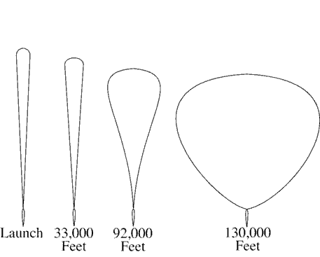
NOTE: These procedures apply to unmanned free balloons that carry payloads as described in 14 CFR Section 101.1(a)(4). Payloads may weigh several hundred pounds and the physical shape of the balloons change at various altitudes/flight levels. (See FIG 9-6-1.) Balloon and payload ascend at an average rate of 400 feet a minute. Over the descent area, the payload is normally released from the balloon and descends by parachute at a minimum rate of 1,000 feet a minute. The balloon is normally deflated automatically when the payload is released. The operator is required to advise ATC 1 hour in advance of descent in accordance with 14 CFR Section 101.39.
- Post the balloon flight on flight progress strips along the planned trajectory and revise routing as tracking/position reports require.
NOTE: The prelaunch notice information should be posted on flight progress strips for planning and operational purposes.
- Radar flight follow balloons to the extent that equipment capabilities permit. If radar flight following is not possible, tracking should be attempted by communication with the “chase plane,” telephone contact with the operator, pilot, or ground observation reports.
NOTE: Some operators have equipped their balloons with transponder beacons in addition to a radar reflection device or material required by 14 CFR Section 101.35, but at cruise altitude, the balloon's communications equipment and transponder, if so equipped, are operated intermittently to conserve battery energy.
- With pilot concurrence, provide separation between aircraft and balloons when you are satisfied that the balloon information is sufficiently reliable to provide the service. Do not attempt to separate aircraft from the balloon by using vertical separation unless you have accurate balloon altitude information.
- Provide traffic advisories to all affected aircraft during initial contact specifying the balloon's known or estimated position, direction of movement, and altitude as “unknown” or “reported,” as appropriate.
NOTE: Unless ATC requires otherwise, operators of unmanned free balloons are required to monitor the course of the balloon and record its position at least every two hours. As required in 14 CFR Section 101.39a, balloon position reports are not forwarded by the operator unless requested by ATC.
- PHRASEOLOGY
- UNMANNED FREE BALLOON OVER (name of location),
- or
- ESTIMATED OVER (name of location), MOVING (direction of movement).
- LAST REPORTED ALTITUDE AT (altitude as reported by the operator or determined from pilot report),
- or
- ALTITUDE UNKNOWN.
- To transfer flight following responsibility of balloons between facilities or between controllers, forward the following information when available:
- REFERENCE
- 14 CFR Section 101.37, Notice Requirements.
- 14 CFR Section 101.39, Balloon Position Reports.
- Identification and type; e.g., Flight 804 Balloon.
- Last known position and altitude.
- General direction of movement and speed.
- ETA over facility boundary, sector boundary, or other point if believed to be reasonably accurate.
- Other pertinent information.
- If in radar contact, physically point out the target to the receiving controller.
- The name and the telephone number of the location where tracking is being accomplished.
9-6-2. DERELICT BALLOONS
Balloons become derelict when a moored balloon slips its mooring and becomes a hazard to air navigation or when an unmanned free balloon flight cannot be terminated as planned. When this occurs:
- In the case of a moored balloon which has slipped its moorings, issue traffic advisories.
- In the case of an unmanned free balloon, flight follow the balloon and, to the extent possible, provide aircraft under your control separation from the balloon.
- Forward balloon position information received from pilot reports or derived from radar returns to your supervisor for further dissemination.
-
If radar contact with the balloon is lost, broadcast an advisory to all aircraft operating in the airspace
affected by the derelict balloon at 10-minute intervals continuing until the derelict balloon is no longer a
factor.
- PHRASEOLOGY
- ADVISORY TO ALL AIRCRAFT.
- DERELICT BALLOON REPORTED IN THE VICINITY OF (location),
- or
- ESTIMATED IN VICINITY OF (location),
- or
- REPORTED OVER (location),
- or
- RADAR REPORTED OVER (location).
- LAST REPORTED ALTITUDE/FLIGHT LEVEL AT (altitude/flight level as reported by operator or pilot report),
- or
- ALTITUDE/FLIGHT LEVEL UNKNOWN.
-
Transfer flight following responsibility as outlined in paragraph 9-6-1, Application, subparagraph e.
- REFERENCE
- FAA Order JO 7210.3, Para 19-5-2, Derelict Balloons/Objects.
Section 7. Parachute Operations
9-7-1. COORDINATION
Coordinate any pertinent information prior to and at the end of each parachute jump or series of jumps which begins or ends in your area of jurisdiction with other affected ATC facilities/sectors.
NOTE: 14 CFR Section 105.15 prescribes the information required from each person requesting authorization or submitting notification for nonemergency parachute jumping activity.
- REFERENCE
- FAA Order JO 7210.3, Para 19-4-1, Nonemergency Parachute Jump Operations.
- 14 CFR Part 105, Parachute Operations.
9-7-2. CLASS A, CLASS B, AND CLASS C AIRSPACE
- Authorize parachute operations only within airspace designated for the jumping activity.
- Separate aircraft, other than those participating in the jump operation, from the airspace authorized for the jumping activity.
- Impose, as necessary, any conditions and restrictions which in your judgment would promote the safety of the operation.
9-7-3. CLASS D AIRSPACE
TERMINAL
Handle requests to conduct jump operations in or into Class D airspace in which there is a functioning control tower as follows:
- Authorize parachute jumping with respect to known or observed traffic.
- Issue advisory information to the jump aircraft and to nonparticipating aircraft as necessary for the safe conduct of the jump operation.
9-7-4. OTHER CONTROL AIRSPACE
Handle notifications to conduct jump operations in other Class E airspace as follows:
- Issue a traffic advisory to the jump aircraft before the jump. Include aircraft type, altitude, and direction of flight of all known traffic which will transit the airspace within which the jump will be conducted.
NOTE: 14 CFR Section 105.13, Radio Equipment and Use Requirements, prescribes that, except when otherwise authorized by ATC, parachute jumping is not allowed in or into Class E airspace unless radio communications have been established between the aircraft and the FAA ATC facility having jurisdiction over the affected airspace of the first intended exit altitude at least 5 minutes before the jumping activity is to begin for the purpose of receiving information in the aircraft about known air traffic in the vicinity of the jump aircraft.
- Issue advisories to all known aircraft which will transit the airspace within which the jump operations will be conducted. Advisories must consist of the location, time, duration, and altitude from which the jump will be made.
- When time or numbers of aircraft make individual transmissions impractical, advisories to nonparticipating aircraft may be broadcast on appropriate control frequencies, or when available, the ATIS broadcast.
- When requested by the pilot and to the extent possible, assist nonparticipating aircraft to avoid the airspace within which the jump will be conducted.
Section 8. Unidentified Flying Object (UFO) Reports
9-8-1. GENERAL
- Persons wanting to report UFO/unexplained phenomena activity should contact a UFO/ unexplained phenomena reporting data collection center, such as the National UFO Reporting Center, etc.
- If concern is expressed that life or property might be endangered, report the activity to the local law enforcement department.